
The satellite industry is entering a new era. Commercial imagery with 10 cm resolution, once the domain of drones and aircraft, will soon be available from orbit. It’s an impressive technological leap that promises unprecedented detail.
But when it comes to monitoring linear infrastructure like power lines and pipelines, more detail doesn’t always mean more value.
Before jumping on the ultra-high-res bandwagon, it’s worth asking:
What actually works when monitoring thousands or tens of thousands of kilometers of critical infrastructure?
This brief guide outlines which resolutions are best suited for different infrastructure monitoring needs: from full-network surveillance to detailed site analysis.
Very High Resolution (30-50 cm): The Proven Standard for Large Area Network Monitoring
When it comes to monitoring expansive infrastructure networks, very high resolution satellite data continues to hit the sweet spot.
Why it works:
- Wide-area coverage — captures hundreds of kilometers in a single image
- High revisit frequency — enables timely updates
- Global availability — supported by mature tasking and delivery systems
- Sufficient detail to identify vegetation encroachment, infrastructure, ground access, and third-party activity
- Cost-effective for regular, long-distance monitoring
How LiveEO raises the bar: At LiveEO, we extend the value of very high resolution imagery with TreeD, our proprietary AI algorithm. TreeD delivers industry-leading vertical accuracy and 3D vegetation detection, outperforming traditional photogrammetry methods. By combining precise 1-meter elevation models with advanced vegetation analytics, TreeD enables utilities to identify risks earlier, prioritize field work smarter, and reduce operational costs, all at scale.
Best for:
- Routine monitoring of power and pipeline networks
- Vegetation management
- Change detection and third-party activity tracking
- Planning and prioritizing field inspections
- Post-storm or flood damage assessment
Limitation:
30–50 cm very high resolution satellite imagery is not suitable for line maintenance applications, as it lacks the fine detail needed to detect structural issues or faults. For these tasks, utilities typically rely on drones, helicopters, or ground inspections to perform high level evaluations or Comprehensive Visual Inspection (CVI).
Ultra-High Resolution (10 cm): Powerful but Not Scalable—Yet
10 cm satellite imagery unlocks further detail, enabling high-level inspection of structures, anomalies, or vegetation features. However, this level of resolution comes with serious trade-offs that limit its effectiveness for wide-area, routine monitoring.
{{inline}}
The trade-offs:
- High cost per km — limits frequency and affordability for long corridors
- Limited availability — early-stage satellite constellations still ramping up
- Small footprint — typically a maximum of a few dozen kilometers per image, and even less for long, linear assets like transmission lines
- Lower revisit rates — fewer opportunities to capture timely changes
While these trade-offs may sound incremental, swath width has a disproportionately large impact on operational feasibility. Ultra-high resolution satellites typically capture only 2–3 km-wide strips only a few kilometers long, making it difficult to follow the linear paths of infrastructure like powerlines. Unlike wide-swath very high resolution satellites, thesenarrow sensors require many more orbits and image captures to cover the same area — and with cloud cover and limited orbit angles, tasking duration becomes longer in a non-linear way.
In practice, covering a long corridor can take up to 10× longer than with today’s standard 30–50 cm imagery with the same amount of satellites. The amount of orbits is limited so the only way to achieve bigger coverage is increasing the amount of satellites. Considering Airbus Pleiades and Pleiades NEO are a constellation of four satellites, it would need ~40 satellites with 10cm to get full grid coverage in the same period of time. As the first satellite just launched, it may take another 5 to 10 years until we will have enough 10cm coverage.
The Bottom Line: It’s not scalable or commercially viable yet for full network monitoring.
However, it’s best used for:
- Special investigations of smaller segments (e.g., encroachment, unauthorized activity) where drone or site access is limited
- Hotspot analysis after storms or failures
- Ground truth validation and inspection support
The following visuals illustrate the practical impact of resolution on coverage and scalability.
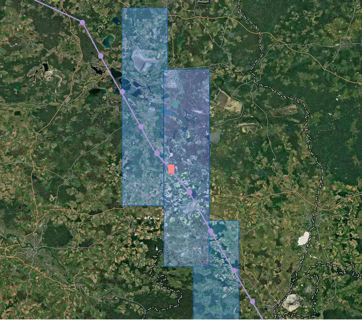
Footprint comparison of 30–50 cm very high resolution (blue) and 10 cm ultra-high resolution (red): While 10 cm offers unmatched detail, its drastically smaller coverage area, with a swath of 2–3 km and a maximum strip length of a few dozen kilometers, makes it best suited for targeted inspections, not routine, full-network monitoring.
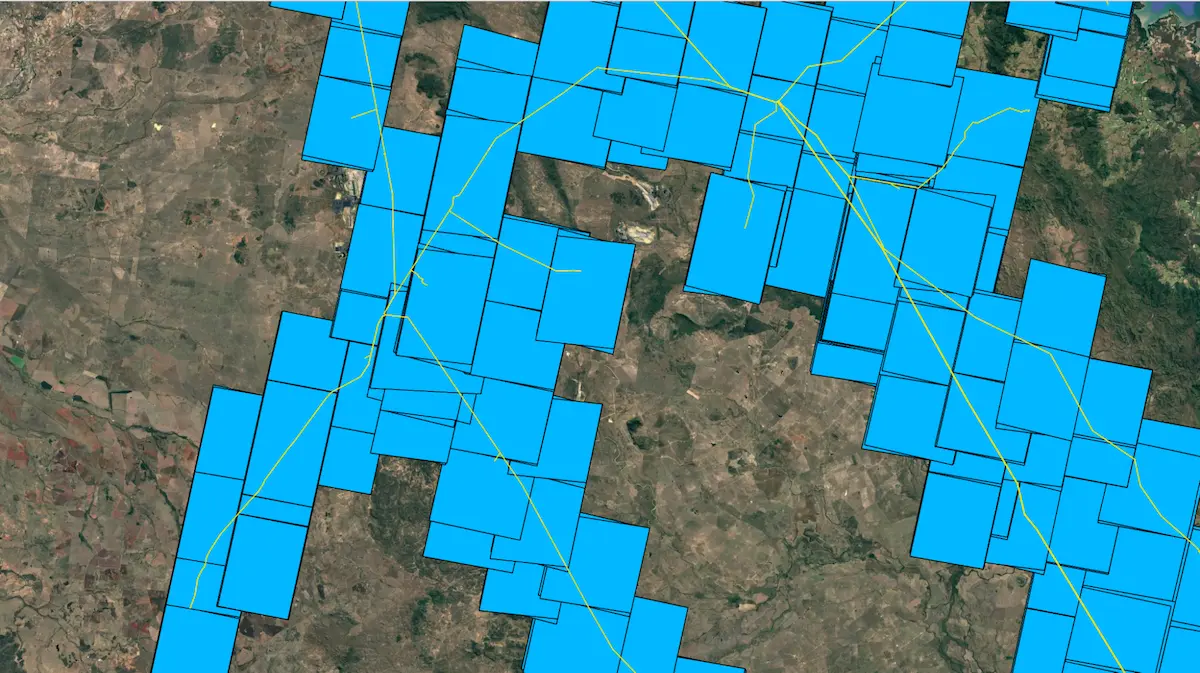
Stereo Tasking footprint of very high resolution (30–50 cm) satellite imagery across a utility network. This level of coverage enables scalable monitoring, vegetation management, and field inspection planning over thousands of kilometers — something not yet feasible with ultra-high resolution satellites.
Detail Isn’t Always Insight
Choosing satellite data for grid monitoring isn’t about chasing the sharpest image. It’s about solving the right problem at the right scale. For utilities and operators looking to stay ahead of risks and improve asset reliability, coverage, cadence, and consistency matter more than individual pixels.
Our View: Focus on What Delivers Value Today
Very high resolution satellite imagery (30-50 cm) remains the most effective and scalable solution for monitoring linear infrastructure. It powers vegetation management, risk detection, and inspection planning across thousands or tens of thousands of kilometers today.
While emerging technologies like 10 cm satellite imagery are exciting, they’re not yet suited for the demands of network-wide monitoring. What matters most right now is proven performance at scale, delivering consistent insights, fast turnaround, and full-network visibility at the right cost.
Schedule a demo to discover how LiveEO’s satellite-based solutions—Treeline for proactive vegetation management and SurfaceScout for third-party risk detection—deliver the coverage, cadence, and insights you need to protect critical infrastructure at scale.