
See The Risk. Stop The Outage.
Treeline transforms reactive vegetation management programs into a predictive, condition-based approach by delivering vegetation intelligence with pinpoint accuracy at scale. This enables utilities to enhance reliability, reduce wildfire and outage risks, and deploy resources more efficiently across their networks.
Trusted by Leading Utilities Worldwide


Managing Vegetation Risk at Scale Is More Complex Than Ever
Vegetation teams face rising pressure to prevent outages, wildfires, and fines, but outdated tools and fragmented workflows make it hard to stay ahead of the risk. Meanwhile, the cost of delivering reliable power keeps climbing, forcing utilities to juggle safety, compliance, and affordability.
Data Overload Without Clear Prioritization
Information pours in from multiple inspection sources, but without automated prioritization it’s hard to know where to act first. The result: decision delays that extend exposure to outages and fire risk.
Siloed Data Creates Friction
Vegetation insights aren’t consistently segmented by geography, so regional teams either lack the visibility they need. This misalignment slows collaboration across vegetation, engineering, and field crews.
Misallocated Resources and Delayed Action
Without a clear risk hierarchy, crews often spend time on lower-priority spans while urgent hazards escalate. Critical work orders are created late, driving both higher costs and higher exposure.
Fragmented Systems Block Scale
Vegetation data is scattered across GIS tools, spreadsheets, and contractor portals. The lack of centralized, role-based access makes it difficult to scale decisions, enforce accountability, or move quickly from detection to action.
Built for Proactive Vegetation Management at Scale
Treeline empowers IOUs, municipalities, and cooperatives to move beyond fragmented, reactive practices with intelligence-driven vegetation management, improving reliability and optimizing the use of limited resources.
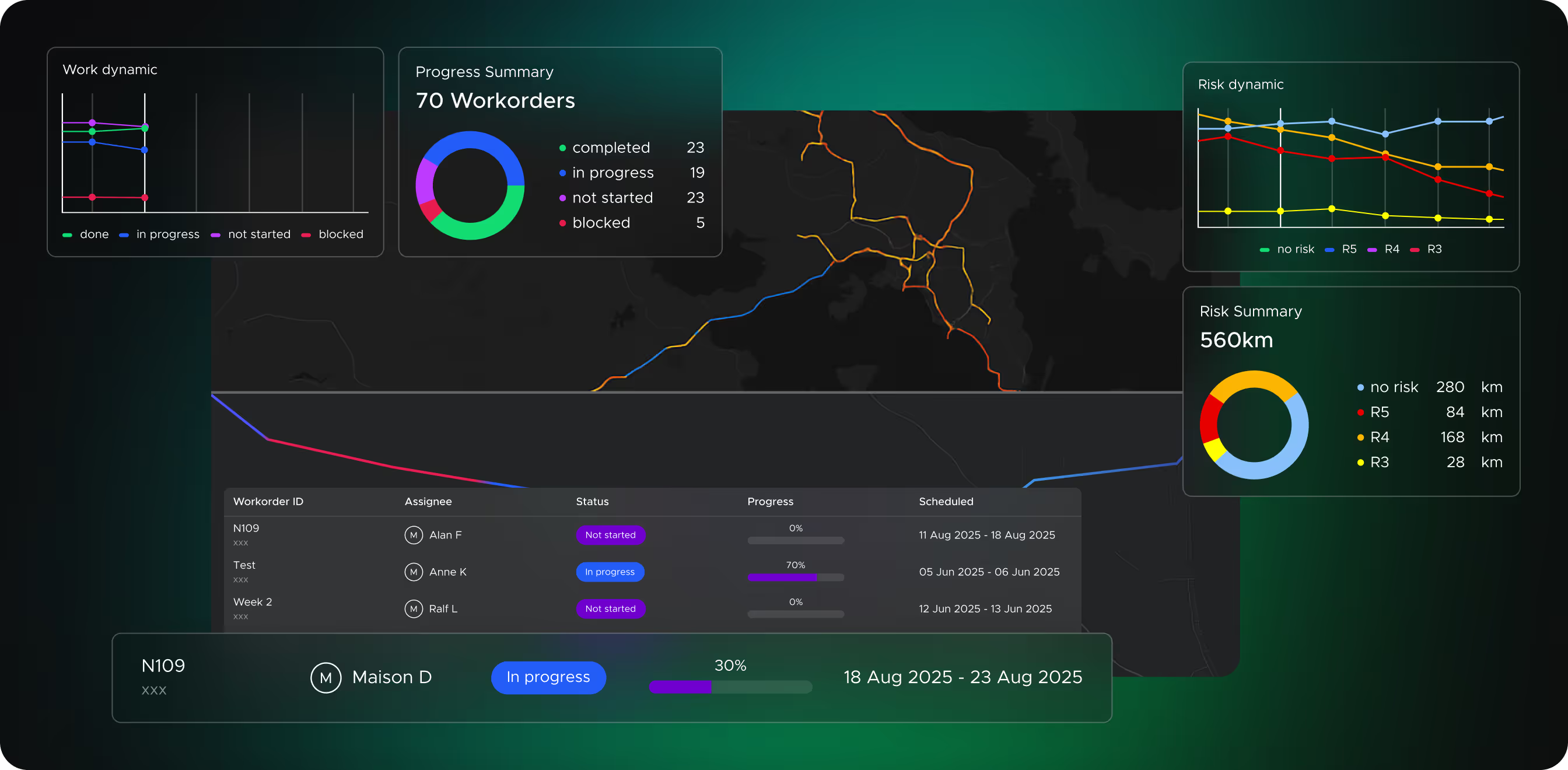
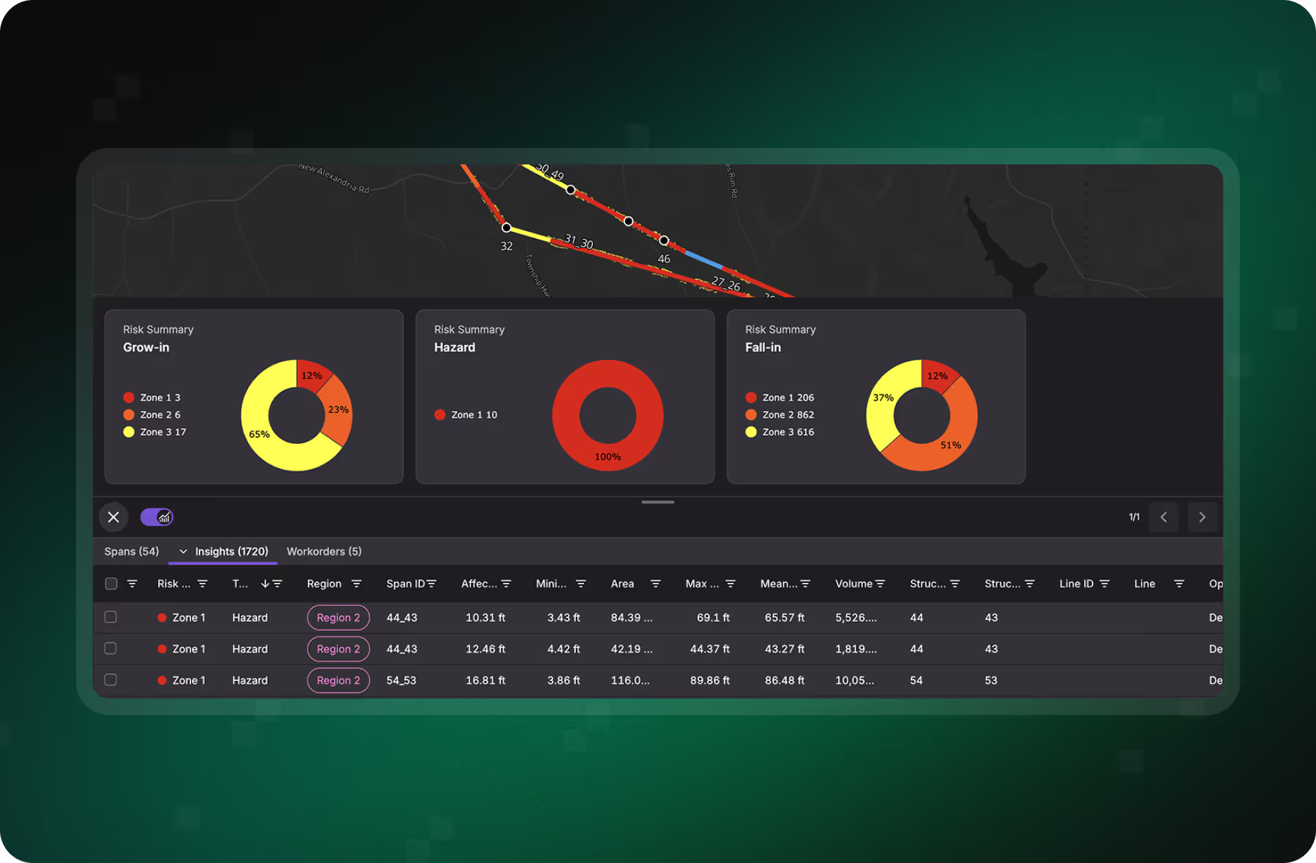
Prioritized Risk Insights
See which lines and spans matter most with multi-attribute detection (grow-in, fall-in, hazard trees) and automated scoring by proximity and criticality.
- Act on the highest-value work first
- Reduce decision latency from months to weeks, or even hours
- Proven results: 41–50% fewer tree-related outages
Region-Based Access and Collaboration
Configurable region-based RBAC is built into Treeline’s core, ensuring every team sees only the insights relevant to their territory. That reduces noise, speeds decisions, and improves collaboration across vegetation, engineering, and field crews.
- Region-scoped dashboards for clear task ownership
- Fewer cross-team bottlenecks and handoff delays
- Better coordination between office and field
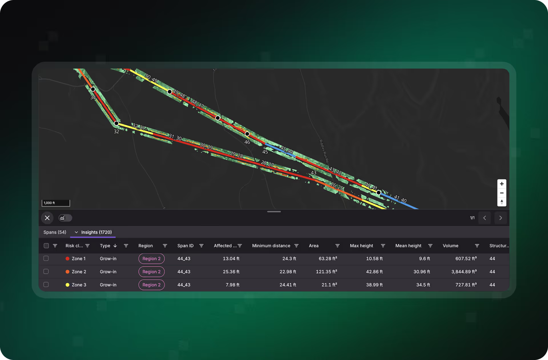
Accuracy You Can Trust
Treeline delivers LiDAR-validated precision without the expense or limits of aerial surveys.
- Sub-meter accuracy: 96% validated accuracy in field validation tests around the globe
- Automatically detect grown-in & fall-in risks, vitality, species and hazardous trees
- Get risk insights in weeks instead of months
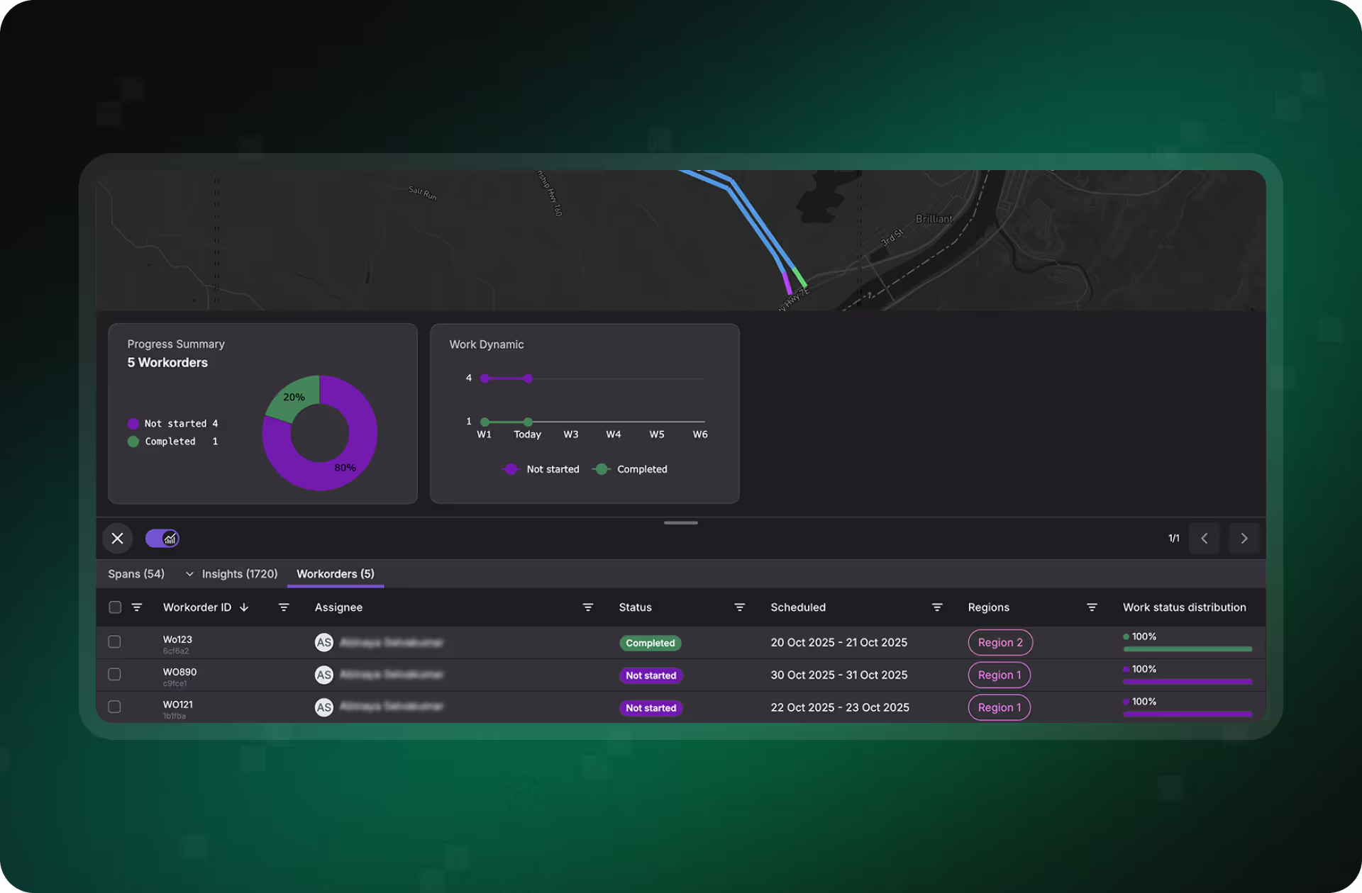
From Detection to Action, Faster
Treeline integrates directly into enterprise asset and work management systems like ESRI, SAP, Clearion, and CityWorks.
- Convert risks into work orders instantly
- Mobile access for field crews with status updates and photo proof
- Ensure teams in the field and office Reduce disputes and rework with verifiable logs

How Utilities Are Using Treeline to Modernize Vegetation Management
Treeline helps operators shift from reactive patrols to predictive, data-driven workflows.
Cycle Optimization
Prune when risk demands it, extending cycles where it’s safe and cutting only where it prevents outages.
Outage Prevention
Catch vegetation hazards early with continuous visibility, reducing emergency callouts and keeping power flowing.
Risk-Based Vegetation Planning
Turn blind spots into actionable risk maps that prioritize the spans most likely to cause outages.
Cutback Audit
Confirm every cutback meets clearance standards with objective before-and-after proof instead of scattered notes and photos.
Proactive Wildfire Defense
Spot wildfire hazards before they ignite and turn high-risk spans into prioritized, defensible action plans.
Ready to Rethink Vegetation Management?
Treeline brings vegetation risk, planning, and verification into one platform, helping operators prioritize threats and act faster with sub-meter accuracy. Let’s explore how we can support your strategy.
How it works
Our solution combines stereo high-resolution satellite data, advanced risk models, and seamless workflows, helping operators see the risk and stop the outage before it happens.
Detect Vegetation Threats Before They Disrupt Your Network
Treeline analyzes stereo high-resolution satellite imagery to identify grow-in, fall-in, and hazard trees with sub-meter accuracy for your entire grid. With continuous, full-span visibility, even beyond the ROW, operators act earlier, reduce outages, and move from reactive patrols to predictive monitoring.
Plan Smarter Trims With Data-Backed Risk Scoring
Every span, feeder, and system is automatically scored by vegetation type, proximity, health, and asset criticality. Region-based dashboards highlight the highest-risk spans first, giving planners a defensible hierarchy for action and helping crews focus where it matters most.
Turn Vegetation Risk Into Actionable Work
Insights flow directly into map-based work orders with built-in QA, routing, and context. Crews receive clear instructions in the field, supervisors track progress in real time, and every job is verified with timestamped, GPS-tagged proof, aligning office and field without bottlenecks.
.avif)
Clear, Defensible Reporting for Every Span, Crew, and Cycle
Treeline packages insights and field data into ready-to-use reports across dashboards, CSVs, and geospatial exports. From geo-tagged photos to audit trails, operators gain verifiable proof of action while saving hours of manual documentation.
Turn Your Vegetation Program Into a Strategic Advantage
From remote terrain to dense networks, Treeline provides grid-wide visibility with no extra headcount. Discover how your team can do more with less.
What Our Customers Are Saying
From regional utilities to national operators, teams are using Treeline’s satellite-powered intelligence to reduce outages, improve compliance, and transform vegetation management into a proactive, data-driven program.
"The LiveEO technology gives us a better overview of the vegetation along our tracks. It allows us to address the consequences of climate change even better."


“Westerville Electric went with LiveEO and our outage rate in 2022 was 18%. We are now at 10%. This is the future of vegetation management!”


"The possibility to check our network with satellite images and AI as well as the strong customer focus of LiveEO have excited us from the beginning. Innovative partners like LiveEO and new technologies are an important pillar for us as a grid operator to make our network even more efficient and reliable."


Save More, Decide Faster, Reduce Risk
See how Treeline helps operators cut costs, improve reliability, and scale vegetation management with outcomes proven across large networks.
Reduce Field Costs
- Replace frequent patrols with scalable, remote monitoring
- Extend pruning cycles in low-risk areas by more than a year
- Optimize contractor planning to reduce truck rolls and rework
Minimize Risk and Outages
- 41-50% fewer tree-related outages reported by operators using Treeline
- Automatically detect vegetation risks for your entire network with pinpoint accuracy
- Get first vegetation risk insights in weeks instead of months
Strengthen Accountability and Collaboration
- Verify contractor work with before/after photo evidence
- Share region-specific insights to improve cross-team coordination
- Integrate vegetation intelligence into your existing workflows and tools via API
Make Vegetation Management Smarter
Replace costly, repetitive patrols with scalable monitoring and smarter contractor planning. Treeline helps extend pruning cycles and cut unnecessary field work. Talk to us about your potential savings.
Why Treeline Is the Strategic Advantage for Grid Resilience
From prioritizing risks to verifying results, Treeline gives your team the accuracy and speed to act with clarity and confidence.
Other solutions
Treeline


FAQs
Find out how Treeline supports the unique needs of electric utilities, from detecting wildfire and outage risks to integrating seamlessly with your existing systems.
In what ways does Treeline differentiate itself from other vegetation management providers?
Treeline is the market leader in AI-powered vegetation management, with the largest partner ecosystem, widest provider range, and proven global utility deployments. This ensures scalability, flexibility, and trusted results across diverse operating environments.
How does Treeline address the challenge of managing large data volumes?
Treeline is cloud-hosted and built for scale. We continuously refine our analytics so that only actionable insights are surfaced, available via web, tablet, or mobile app, enabling utilities to make fast, informed decisions.
How reliable is satellite-based monitoring under variable weather conditions?
With high data volumes and recurring scans, coverage gaps are minimized. Treeline combines multiple data sources and frequent updates to deliver reliable, consistent visibility across the network, at a lower cost than traditional methods.
How easily does Treeline integrate with existing utility systems?
Treeline is designed to meet utilities where they are. Insights can be accessed through our application, exported in common geofile formats, or integrated directly into ESRI, SAP, or WFM systems via API.
What is the cost justification for adopting satellite-based vegetation monitoring?
Treeline delivers strong ROI by helping utilities optimize trim cycles, reduce emergency callouts, and avoid costly outages or wildfire liabilities. Our precision forecasting of pruning needs creates efficiencies that static patrol schedules can’t match.
Is adopting Treeline disruptive to our current vegetation workflows?
Not at all. Treeline is designed to complement and enhance your current processes. We provide multiple integration options — including direct API access, ESRI compatibility, and geospatial exports — so you can adopt the solution without disrupting your existing operations.