
The adoption of LiDAR has been an important step in digitizing vegetation management. While there likely will be some applications of laser scanning, satellites will monitor the bulk of infrastructure networks.
LiDAR is an amazing technology: To see real-world objects turned into digital 3D representations is awe inspiring for most people witnessing it for the first time. Just recently, Apple started to equip the newest editions of iPhones and iPads with LiDAR scanners to enable better depth scanning for photos: Many of us will be carrying around LiDAR scanners in our pockets very soon.

Some new iPhones feature LiDAR scanners
In Vegetation Management, the technology has played an important role to digitize the process of identifying risks along the network. Areas hard to reach on the ground could still be analysed with a LiDAR-equipped helicopter at a far greater pace than walking/driving along the grid and with greater precision and broader attention than the human eye looking down on the assets. However, facts suggest that the technology has exceeded its zenith in the area of vegetation management.
With the industry’s adoption of LiDAR, its limitations have become obvious
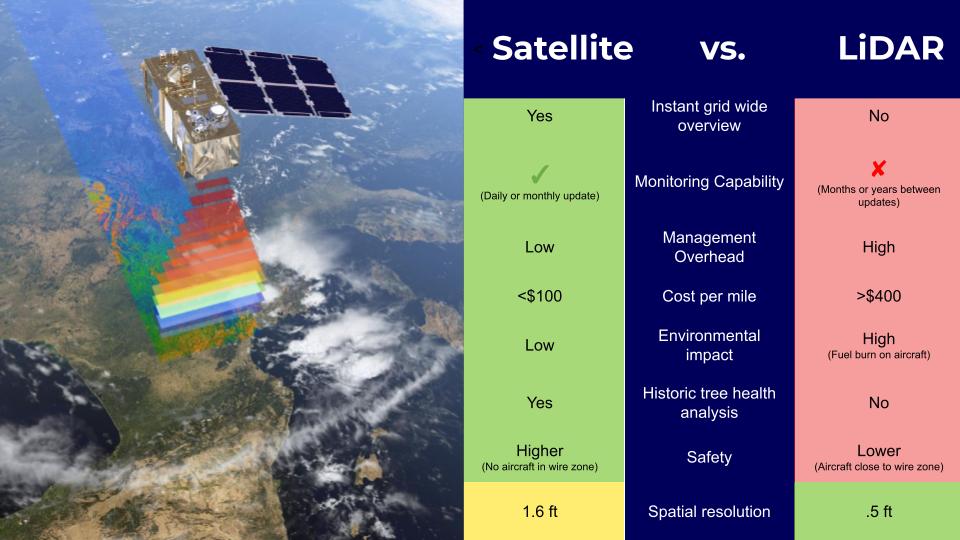
It is mostly consensus by now, that the price tag of LiDAR helicopter flights, ranging from $400 to $700 per mile, is hard to justify to use on distribution networks. As a consequence, mostly transmission networks are using LiDAR today only for parts of their grid.
Consequently, vegetation managers are still left in the dark with no data for major parts of their assets or are forced to rely on ground patrols visually inspecting the condition on-site, which again involves high cost per mile, long turnaround times, and the challenge to incorporate the insights generated from the inspections into a bigger picture.
As the helis fly over the powerlines, only a snapshot of the vegetation’s condition is being captured, which then typically takes a few months to be delivered to the utility. Fast-growing trees that pop up during the peak growing season (‘cycle busters’) are routinely missed because of the long turnaround time. Moreover, the data coming on from different sources at different points in time makes it difficult to effectively prioritize cutbacks and inspections on a risk basis.
With society becoming more environmentally conscious every year, utilities face a dilemma if they want to expand their monitoring capabilities using helis operated with Jet A-1 fuel while simultaneously reducing their carbon footprint. Lastly, despite being rare thanks to strict safety protocols and well-trained pilots, wherever flying vehicles are operating, accidents includingfatalities can and do occur.
Satellites do it all - and most of it better
Thanks to a great increase in the availability of high-resolution satellite data, combined with advances in machine learning and AI, satellite monitoring has become a viable alternative to LiDAR for infrastructure monitoring, with several advantages.
In direct comparison, the benefits of satellites are obvious
Today it is possible to monitor country-scale infrastructure networks from space, as LiveEO has been doing for the largest European railway operator, Deutsche Bahn, as well as among others for Portuguese electric utility EDP. The cost per mile of satellite analysis is a fraction of what has to be spent on helicopter flights, resulting in a good ROI also on the distribution level.
{{inline}}
LiveEO’s purpose-built vegetation management software can accurately identify vegetation along the grid. With all data coming from one source, namely the satellite images, vegetation managers are provided with a grid-wide overview of their network and vegetation close to it.
The highest resolution satellite images allow for detection of horizontal encroachment in the ROW with an accuracy of 1-1.5 ft. /.3 - .5m To the surprise of many, satellites are capable of capturing the canopy height as well. Using stereoscopic imagery, tree heights can be detected with an accuracy of 5 ft / 1.5m, which is admittedly less accurate than LiDAR, but sufficient for most use cases.
With the satellites circling the orbit anyway at any given time, it is possible to obtain insights on the network’s condition much faster and for vast areas compared to helicopters or ground patrols. Actionable deliverables are generated within weeks, instead of months. With frequent updates throughout the growing season, near-real-time monitoring becomes a reality and cycle busters can be detected. Some of our customers use high-frequency monitoring to validate cutbacks by subcontractors; monitoring tree vitality throughout the season is another use case.
With no fuel being used, switching to satellite-based monitoring can help utilities that aim to reduce their carbon footprint while at the same time lowering the risk of work-related accidents.
Satellites are becoming the industry standard
LiDAR indeed offers an even higher resolution than satellite imagery, which is why there will most probably still be applications for the technology on an ad-hoc basis for specific parts of the grid. For most applications though, satellite analytics is the go-to option in vegetation management, as insights are delivered more rapidly, at a higher frequency, with lower safety issues, with lower impact on the environment, and for the whole network at once.
Get in touch!