San Joaquin: Can Its Future Be Protected?
The San Joaquin Valley is notorious for having the biggest shortfall of groundwater in California, experiencing significant repercussions from over-extraction, such as severe land sinking. Persistent over-extraction of groundwater and the consequent land shift can amplify the likelihood of expensive damage to surrounding infrastructures like buildings, highways, train tracks, airports, and pipeline systems.
The damage is so severe, hundreds of thousands of acres of farmland and thousands of jobs are at high risk.
In History: San Joaquin’s Early Exploitation
San Joaquin has been subject to exploitation of its aquifer systems for farming that, over time, resulted in heavy degradation of its natural water sources, permanently lowering water levels. In addition, reduced water on the surface of San Joaquin led to over-pumping of its underground water reservoirs. Because agriculture in San Joaquin is one of its main economic drivers, farmers utilized its aquifers to propel water use during drought, which consequently resulted in not just a decrease in water supply, but significant ground deformation and subsidence.
In addition, groundwater recharge depends on rain received throughout the year, which can vary due to the aforementioned drought conditions.
LiveEO’s in depth solutions can help access data that provides valuable insights. By harnessing the power of satellites, organizations can make informed decisions to protect and enable their assets. LiveEO is always working to promote conservation, aiding sustainability and protecting the Earth in the process.
LiveEO analysis indicates severe ground subsidence
Our three-year analysis unveiled an increase in deformation of up to 600 millimeters, suggesting profound consolidation processes that could potentially impact not only transportation infrastructures like roads and highways but also assets across various industries.
Synthetic aperture radar (SAR) images are used to measure deformation, or changes in the Earth's surface over time. Deformation can be observed through line of sight (LOS) deformation for each orbit direction (ascending and descending), which measures the displacement along the radar beam.
Estimated LOS velocity map in the San Joaquin surroundings:
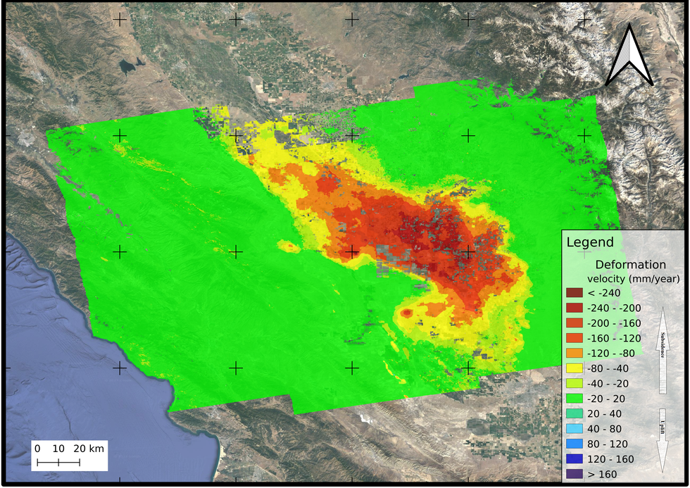
However, to gain a comprehensive understanding, the LOS deformation needs to be decomposed into its horizontal and vertical components. Horizontal and vertical decomposed deformation separates the total displacement into the east-west direction (horizontal) and the vertical direction (perpendicular to the Earth's surface). This decomposition provides valuable insights into the actual movement of the ground and aids in the analysis of geological processes.
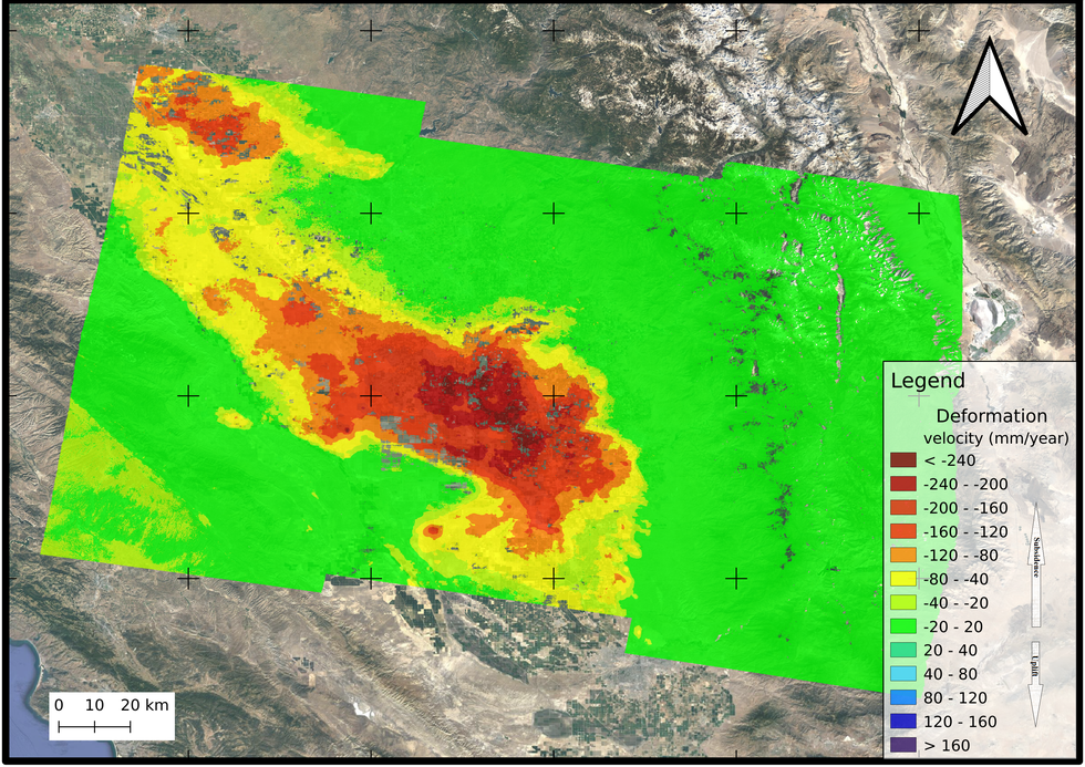
Decomposed velocity map obtained from results in both orbit directions:


In this scenario, the satellite captures line of sight (LOS) deformation measurements in both directions. However, upon decomposing these vectors, it becomes evident that the horizontal deformation in this particular area is of minimal significance. The predominant direction of deformation is primarily aligned with the vertical axis, revealing substantial areas of land undergoing subsidence.
The study conducted by LiveEO on land subsidence in San Jose demonstrated solid concordance with the InSAR Land Subsidence Data from the California Department of Water Resources, affirming the effectiveness of our data processing methodology.
{{inline}}
In order to guarantee the precision and authenticity of our conclusions, we also validated our results against the Global Navigation Satellite System (GNSS) ground truth data. The deformation trends uncovered in our study aligned closely with those identified through GNSS measurements, with a minor discrepancy ranging between 3.6 - 5.4 mm/year, thereby reinforcing the credibility of our results.
Protect Your Assets with Insights from Space
LiveEO’s analytics, in this case, could have saved not just time, but valuable resources. React preventatively instead of retroactively, and book a demo or ask away here.