
Always-On Monitoring That Spots Threats Before They Escalate
SurfaceScout combines high-resolution satellite imagery and AI to continuously detect third-party activity and natural hazards across your entire pipeline, even in restricted or remote areas. With time-based change detection, automated prioritization, and real-time alerts, you can catch risks early, take action faster, and prevent costly incidents before they unfold.


Trusted by Leaders Worldwide


Eliminate Blind Spots.
Spot Risks Sooner.
Operators often miss early signs of third-party interference or natural hazards due to the limits of patrol-based monitoring. SurfaceScout fills those gaps with always-on satellite visibility, detecting subtle changes and emerging threats in places traditional methods can’t reach, from dense cities to remote terrain.
Stop Playing Catch-Up with Pipeline Risk
From unauthorized digging to slow-developing erosion, SurfaceScout flags risks early, giving your team the head start needed to avoid damage, downtime, or regulatory violations.
Maintain Full Visibility, Year-Round
Satellite imagery covers every part of your network, no matter the weather, terrain, or access restrictions. That means no more gaps from grounded flights or inaccessible zones.
No More Wasted Patrols
With prioritized, AI-flagged events, field teams focus only where there’s real risk. That means faster response times, fewer false alarms, and lower inspection overhead.
Better Awareness, Lower Liability
Eliminate blind spots that lead to damage, downtime, and non-compliance. With a complete view of your pipeline corridor, you can act with confidence, and prove it.
Always-On Monitoring,
Without the Blind Spots
SurfaceScout replaces slow, manual inspections with AI-powered satellite monitoring that covers your entire pipeline network, from cities to remote terrain. Get real-time visibility into emerging third-party threats and natural hazards, without ever setting foot on-site.
Monitor All of Your Network, No Matter How Remote
SurfaceScout uses satellite imagery to scan your entire pipeline corridor, including urban zones, high-security areas, and terrain inaccessible by ground or air. Operators get consistent updates across the full asset footprint, without needing to dispatch a single patrol.
- 100% coverage across rural, urban, and no-fly zones
- Weekly or biweekly satellite image delivery
- Scalable monitoring without additional field resources
Day or Night, Rain or Shine, We’ve Got You Covered
By combining optical imagery with SAR (Synthetic Aperture Radar), SurfaceScout provides reliable detection in any conditions, through cloud cover, darkness, and adverse weather, so your monitoring never goes dark.
- Optical and SAR satellite imagery
- Visibility in all-weather, low-light, or night-time scenarios
- No inspection delays due to weather or airspace restrictions
.avif)
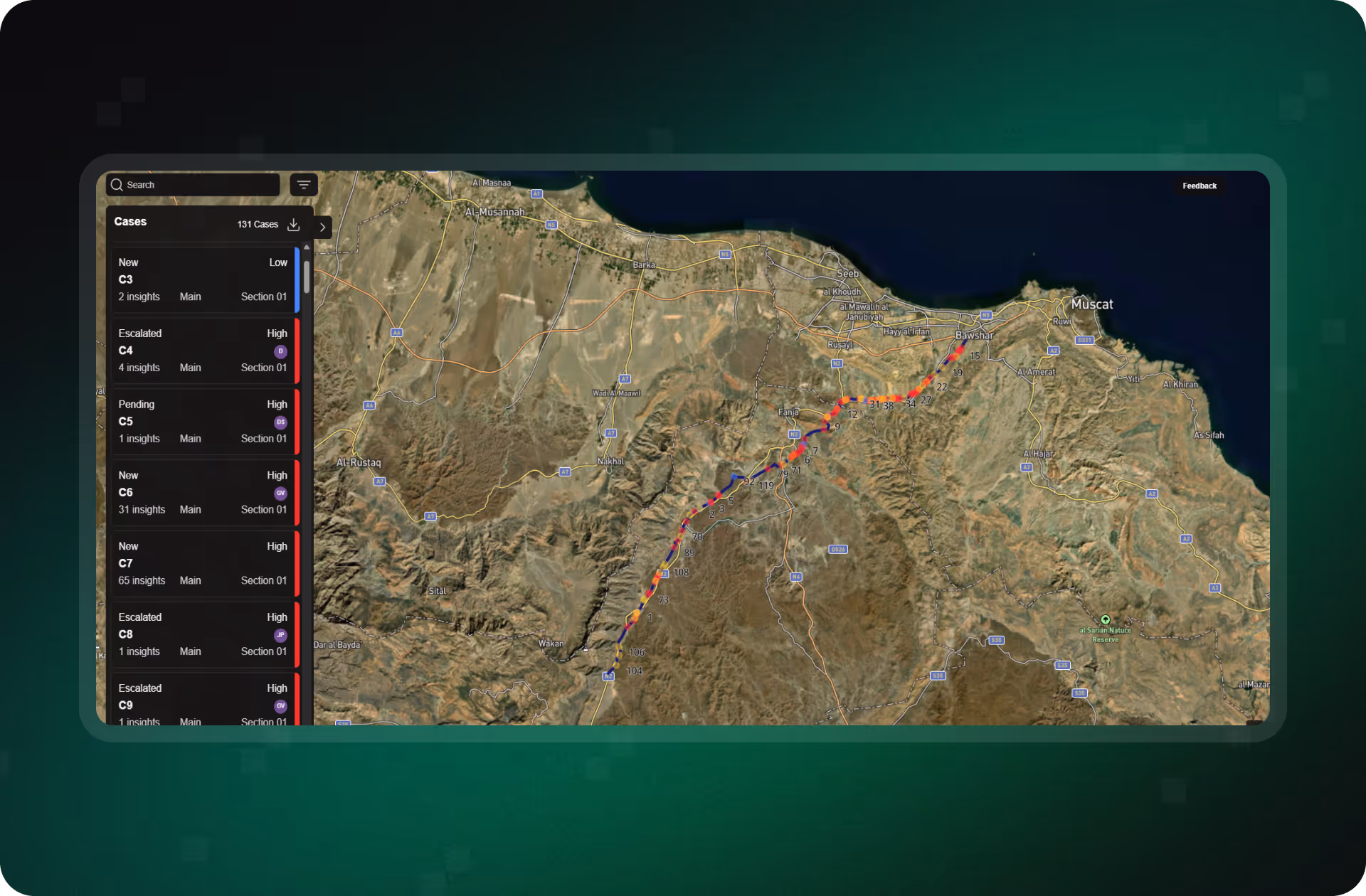
Real Threats, Spotted in Near-Real Time
SurfaceScout’s AI models are trained to detect unauthorized construction, excavation, and natural hazards like erosion or waterbody expansion, with high precision and minimal false alarms.
- Proprietary ML models trained on oil & gas risk signals
- Flags third-party activity and environmental changes
- Reduces false positives and alert fatigue

Detect What’s New, Before It Becomes a Problem
Our platform compares satellite imagery over time to spot meaningful changes. That means catching new threats early, even if they develop gradually, and responding before escalation.
- Change detection based on multi-temporal satellite imagery
- Surface slow-developing threats that patrols often miss
- Accelerates detection of both man-made and natural risks
.avif)
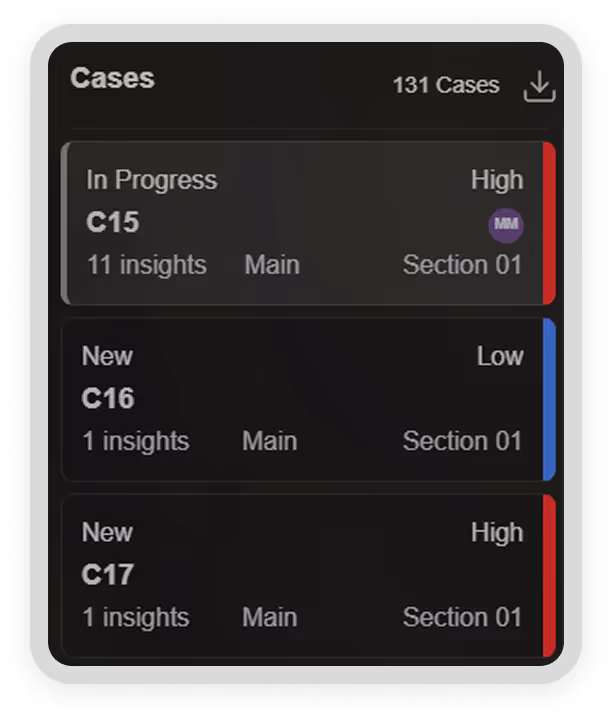
Focus Field Teams on What’s Urgent
SurfaceScout doesn’t just detect risk, it prioritizes it. Events are scored by type, severity, and proximity, so you can deploy resources where they matter most and eliminate unnecessary site visits.
- Automated criticality scoring
- Reduce unnecessary fieldwork and travel
- Help field teams act instead of investigate
Stay Ahead of Pipeline Risk, With Zero Blind Spots
See how SurfaceScout’s always-on satellite monitoring helps you detect critical threats earlier, reduce inspection costs, and deploy teams faster, all without sending anyone into the field.
What Proactive Pipeline Monitoring
Looks Like in Practice
From global energy majors to regional operators, teams are using SurfaceScout to replace reactive patrols with continuous satellite oversight. Explore how customers are detecting threats earlier, cutting field costs, and staying audit-ready, all with a smarter, scalable approach to risk.


.avif)
FAQs
Learn how SurfaceScout uses satellite imagery and AI to monitor your pipeline in near real time. From data sources and update frequency to detection capabilities and prioritization logic, here’s what you need to know about how we help you detect risk before it escalates.


What types of risks can SurfaceScout detect?
SurfaceScout detects third-party interference (e.g., digging, construction) and natural hazards (e.g., erosion, terrain shifts, waterbody expansion) using AI models trained on pipeline-specific risk signals.
How frequently is satellite imagery updated?
Imagery is delivered on weekly or biweekly cadences, configurable to your operational needs. SAR ensures visibility in all weather, at night, or in cloud-covered regions.
How does prioritization work?
Each detected risk is scored by severity, type, and proximity to your assets. This helps teams focus resources on the most critical threats first — reducing false alarms and inspection overhead.
Does SurfaceScout require additional sensors or hardware?
No. SurfaceScout is 100% satellite-based and cloud-delivered. No field equipment, installation, or hardware maintenance is needed.