
Vegetation Risk Prioritization Built for Grid-Scale Decision Making
Treeline uses high-resolution satellite imagery and AI to automatically detect and classify vegetation risks across your entire grid, including grow-in, fall-in, and hazard trees. Gain full-span visibility across and beyond the right-of-way, so you can act earlier, reduce outages, and trim smarter, without waiting for the next patrol or LiDAR scan.
Trusted by Leaders Worldwide


Stop Guessing Trim Priorities.
Target the Spans That Carry the Most Risk.
When vegetation work plans aren’t backed by risk data, teams default to mileage-based trimming or legacy cycles, wasting time, overcutting low-risk areas, and missing the spans that matter. Treeline’s Risk Prioritization Engine changes that with system-wide, auditable scoring that helps utilities target high-risk spans, justify budget, and move from reactive cleanup to proactive planning.
Planning Without Risk Data Is a Liability
Without consistent risk scoring, UVM decisions rely on judgment, historic routes, or outdated maps. Treeline adds structure with span-level rankings tied to actual exposure, criticality, and vegetation risk.
Your Next Trim Shouldn’t Be a Guess
Inconsistent prioritization leads to misallocated crews, ballooning costs, and delayed risk reduction. Treeline helps you prioritize by severity, proximity, and system impact, not just distance or time.
Smarter Budgets, Easier Approvals
With a transparent scoring model and map-based visualization, Treeline helps you defend plans to regulators, executives, and finance teams, showing exactly where the next dollar delivers the most impact.
Fewer Missed Spans. Less Rework. More Control.
Targeted work plans mean fewer surprises, better contractor alignment, and less rework. Treeline reduces planning friction and keeps everyone, from GIS to field ops, on the same page.

"LiveEO’s technology has the potential to drive down our SAIDI and SAIFI, reduce service restoration costs, and help us allocate resources more effectively during storm restoration efforts, making it an invaluable tool for improving our overall system reliability and customer satisfaction...”

.webp)
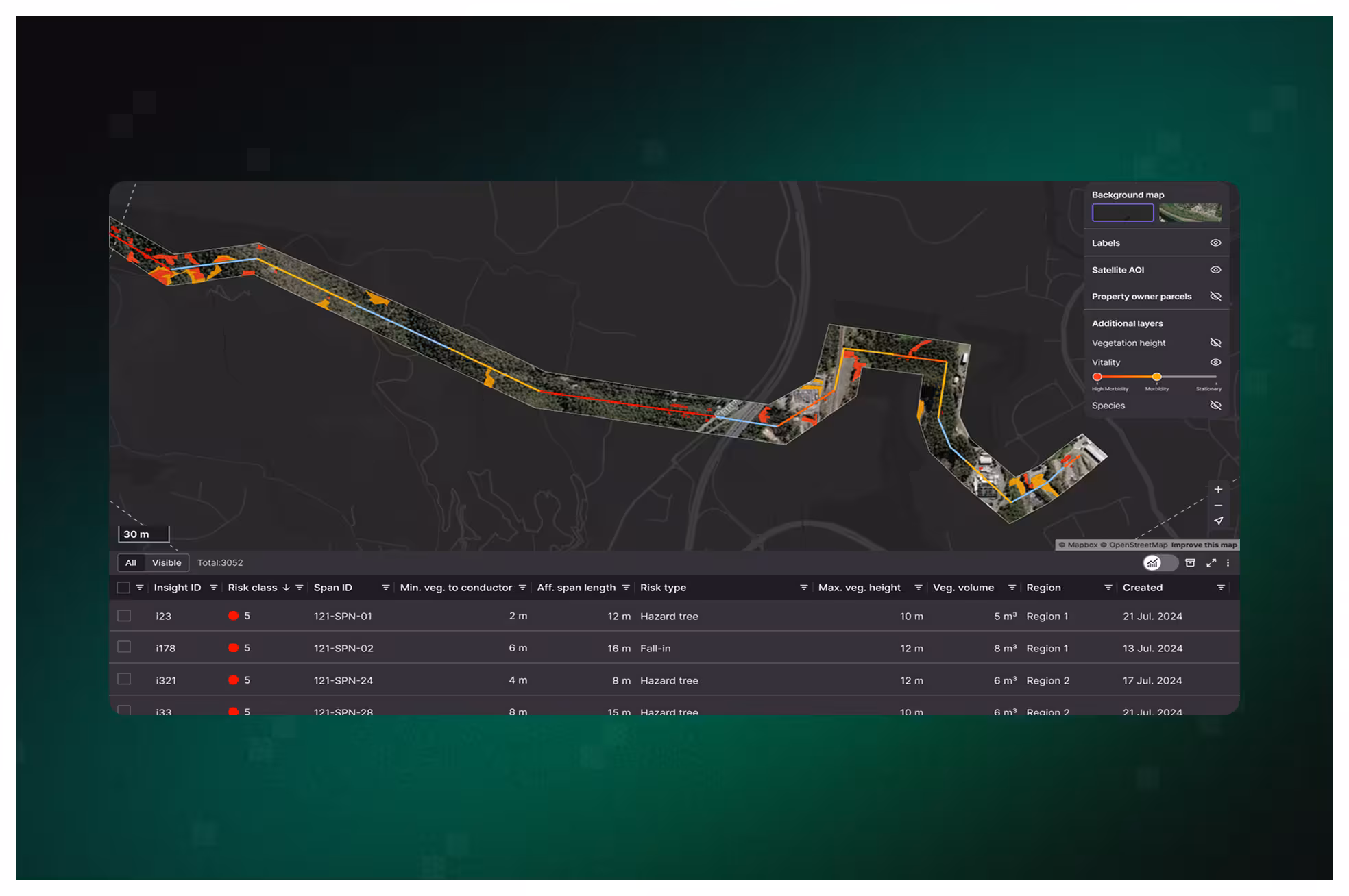
Prioritize High-Risk Spans With Data You Can Defend
With color-coded dashboards, export-ready work items, and seamless GIS/WFM integration, you can turn raw insights into risk-reducing field plans, faster, and with confidence.
Rank Every Span, Justify Every Cut
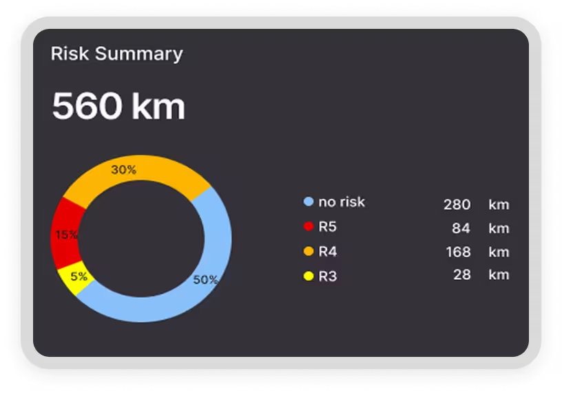
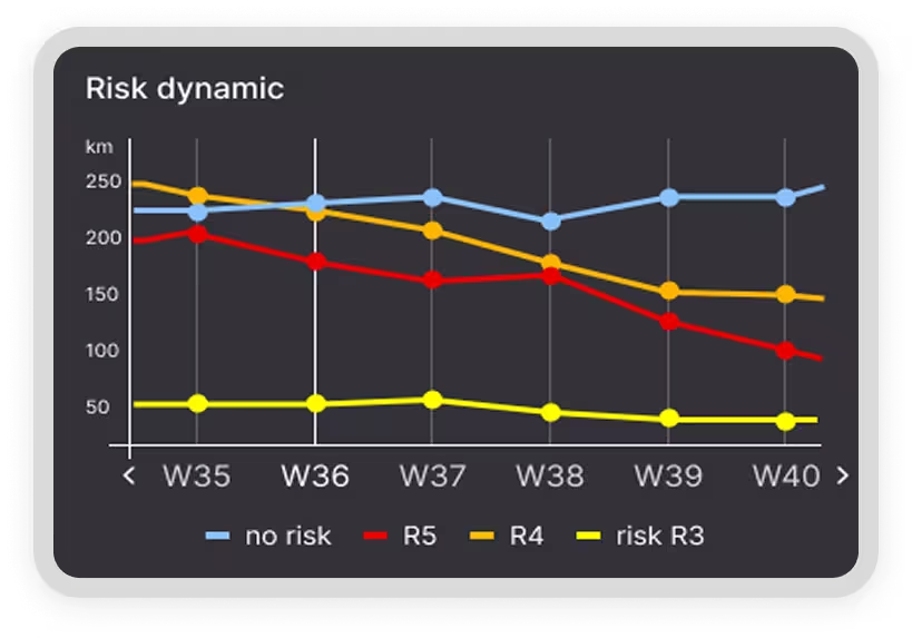
Treeline calculates multi-factor risk scores at the span, feeder, and system levels, factoring in vegetation type, proximity, health, and asset criticality. These scores help you triage where to act first, so crews are deployed where they’ll make the biggest impact.
- Prioritization based on risk type, severity, and exposure
- Supports circuit-level planning and regulatory reporting
- Ensures consistency across service territories and teams
.avif)
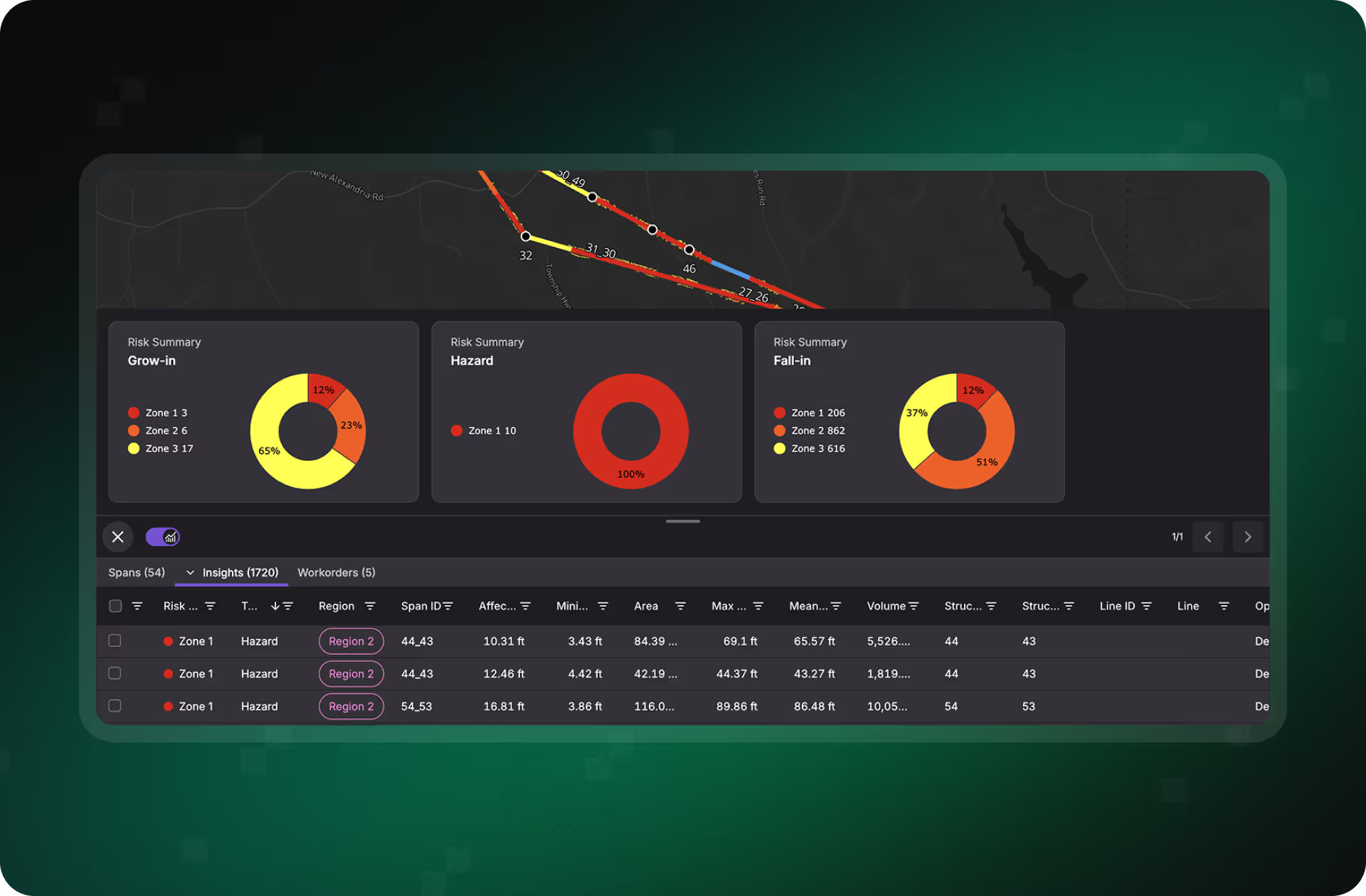
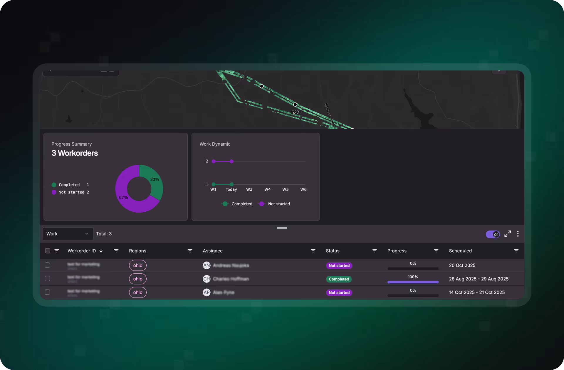
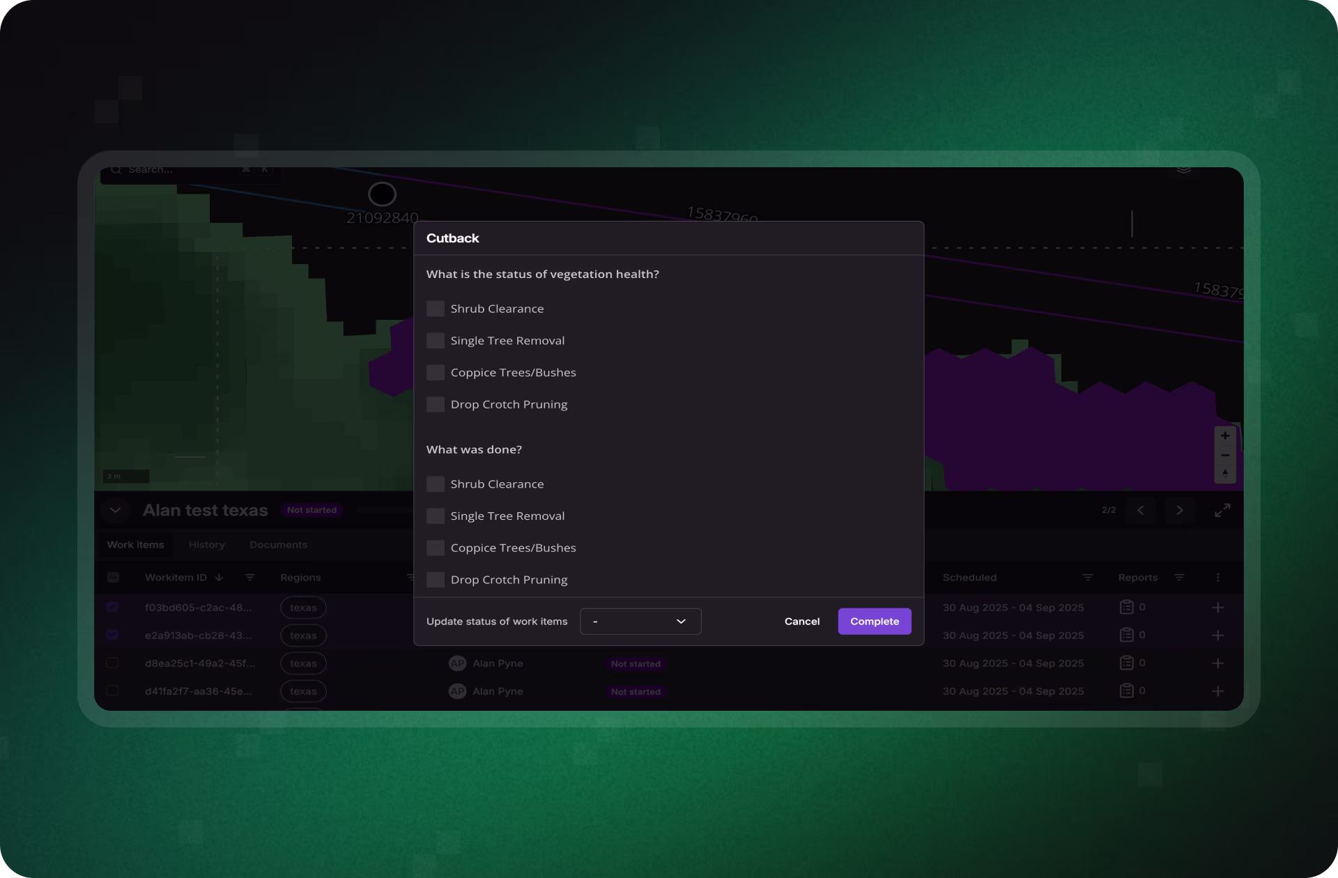
From Risk Insight to Field Action
Selected risks become scoped work items, exportable to WFM, GIS, or contractor platforms via API. Treeline also logs each update in a shared audit trail, so nothing gets lost between planning and execution.
- One-click conversion of insights to scoped tasks
- API integration with ESRI, SAP, Trimble, Clearion & more
- Automatic change logs and traceability across teams
Turn Vegetation Insights Into Defensible, Data-Driven Action
See how Treeline helps utilities prioritize the highest-risk spans, align teams around what matters most, and build vegetation plans that are faster to execute, and easier to defend.
What Smarter Vegetation Management
Looks Like in Practice
See how real teams are transforming grid reliability with proactive, satellite-powered insights.
"The LiveEO technology gives us a better overview of the vegetation along our tracks. It allows us to address the consequences of climate change even better."


“Westerville Electric went with LiveEO and our outage rate in 2022 was 18%. We are now at 10%. This is the future of vegetation management!”


"The possibility to check our network with satellite images and AI as well as the strong customer focus of LiveEO have excited us from the beginning. Innovative partners like LiveEO and new technologies are an important pillar for us as a grid operator to make our network even more efficient and reliable."


FAQs
Get clarity on how Treeline turns raw vegetation data into actionable plans, from how risk scores are calculated to how they power work order generation and crew allocation.


How does Treeline calculate vegetation risk scores?
Treeline uses a multi-factor scoring system that considers vegetation type, proximity, health, and span criticality. Each span is evaluated based on likelihood and potential impact, producing defensible scores for feeder, circuit, and system-level prioritization.
Can we adjust how risk is prioritized?
Yes. Treeline’s scoring logic can be tailored to reflect utility-specific priorities, such as fire zones, customer density, or historical outage data, so that your highest-impact spans are always surfaced first.
How does this help with planning and budgeting?
Treeline enables data-backed decisions by tying each planned work item to a quantified risk score. This helps utilities justify spend to regulators and executives, avoid over-servicing, and optimize crew assignments based on actual risk, not just mileage or FIFO.
Can we export risks directly to our work management system?
Absolutely. Treeline integrates with WFM and GIS tools (e.g., SAP, ESRI, Trimble, Clearion), allowing you to select risks and export them directly as structured work orders. This reduces manual data handling and ensures alignment between planning and execution.
Does the system track changes to prioritization over time?
Yes. Treeline includes full change logs and audit trails for every risk insight. Updates are tracked and visible across users, making it easy to trace when and why a span’s priority changed.