
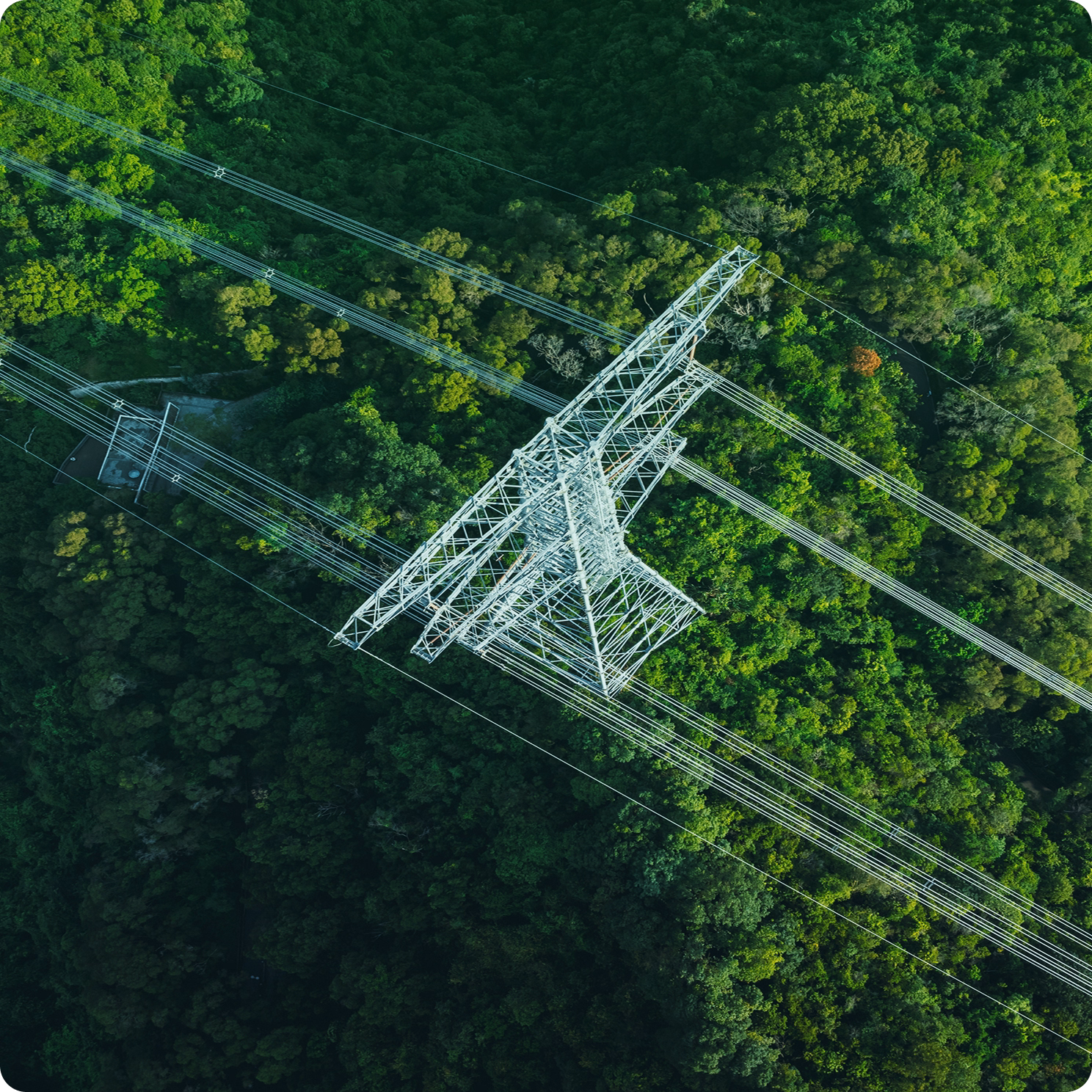
Detect Vegetation Threats Before They Disrupt Your Network
Treeline uses high-resolution satellite imagery and AI to automatically detect and classify vegetation risks across your entire grid, including grow-in, fall-in, and hazard trees. Gain full visibility across and beyond the right-of-way, so you can act earlier, prune smarter, and reduce outages, without waiting for the next patrol or LiDAR scan.
Trusted by Leaders Worldwide


Eliminate Vegetation Blind Spots.
Strengthen Grid Resilience.
Vegetation risk evolves quickly, and traditional monitoring can’t keep up. When patrols are infrequent and LiDAR scans delayed, high-risk spans slip through the cracks. Treeline solves this by delivering full, continuous visibility across and beyond the ROW, so utilities can detect grow-in, fall-in, and hazard trees before they disrupt service or trigger regulatory action.
Too Many Blind Spots. Not Enough Span-Level Insight.
Grow-in, overhang, and fall-in risks are missed when patrols are delayed or incomplete. Treeline delivers standardized, span-level detection across your full network, helping you find threats before they escalate.
Fall-In and Hazard Trees Don't Wait for the Next Patrol
Off-corridor threats, like dying or leaning trees, often go undetected until it’s too late. With satellite-based detection and health insights, Treeline gives you visibility where boots and helicopters can’t.
Delayed LiDAR = Delayed Action
Annual or biannual scans leave massive gaps in situational awareness. Treeline fills those gaps with recurring, high-resolution monitoring, so your insights are always up to date and operationally useful.
From Reactive to Predictive UVM
Without early warning, vegetation management stays reactive. Treeline helps you move to condition-based planning by identifying high-risk spans before they become high-cost incidents.

“Using Treeline, I can request the data and hit the ground running before there’s a lot of change in the environment. The app is visual, it’s quick, and it has a different risk color depending on the distance away from the conductor. It’s visually more appealing and informational than lidar points with classifications."
.webp)
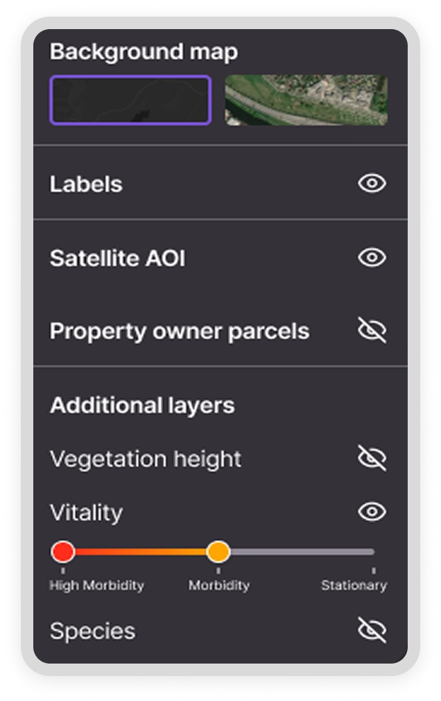
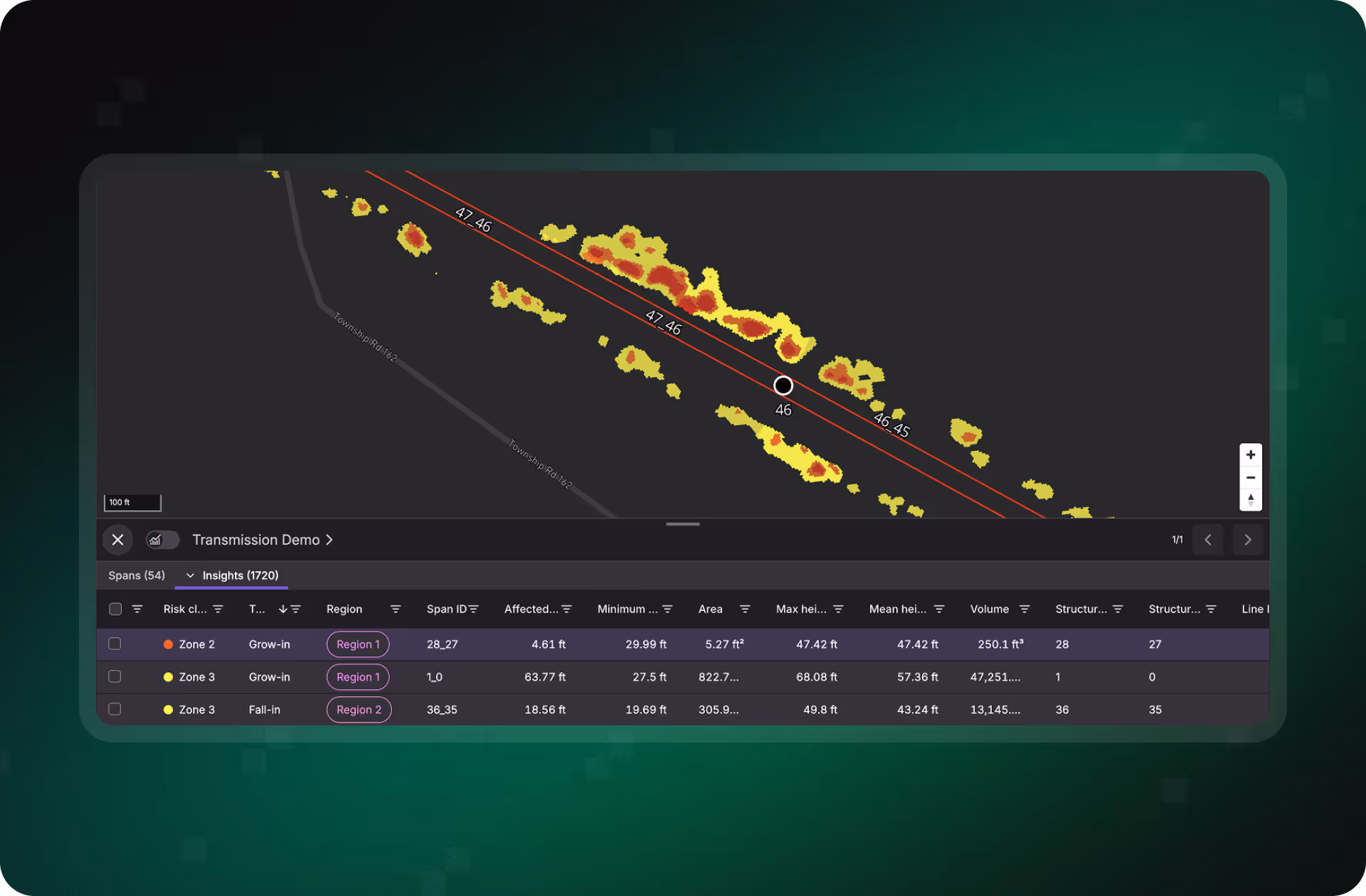
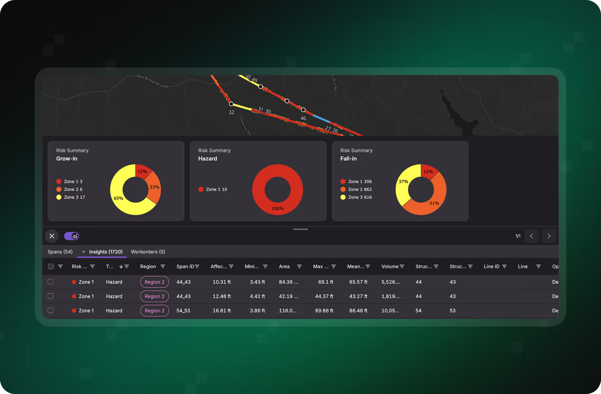
Automated Detection That Keeps Up With Changing Risk
Treeline transforms vegetation risk monitoring from sporadic inspections into a continuous, automated process. By combining satellite imagery, elevation data, and AI, Treeline delivers accurate, span-level visibility into encroachment, hazard trees, and vegetation health, all updated on a cadence that fits your operational needs.
Precision Insights From Space
Treeline uses stereo high-resolution imagery to create a 3D view of vegetation across and beyond the corridor. This enables accurate detection of vegetation height, proximity to conductors, and off-ROW fall-in risks, without boots on the ground.
- Accurate vegetation height and proximity estimates
- Detect grow-in, overhang, and fall-in threats
- Supports both T&D spans across wide geographies
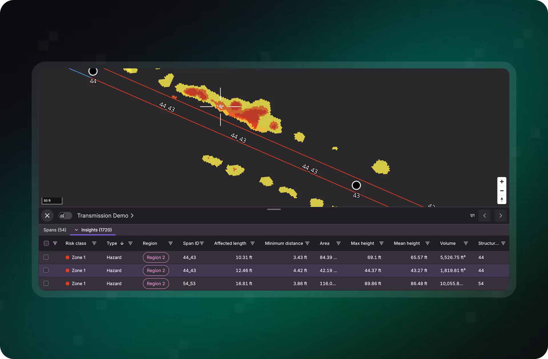
Spot Tree Decline Before It Becomes a Threat
By analyzing vegetation vitality over time, Treeline identifies dying, leaning, or diseased trees that may pose future threats, even when they’re outside the immediate ROW.
- Multi-year insights of vegetation health
- Identifies slow-developing or off-corridor risks
- Enables earlier intervention before failure or ignition
%20new.avif)
Know What You're Dealing With
Treeline can distinguish between coniferous and deciduous tree families in areas where satellite data supports classification. This gives utilities additional insight into species-specific risk and planning strategies.
- Differentiates vegetation types for context-sensitive planning
- Supports species-based prioritization or intervention
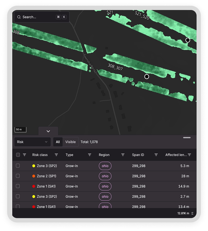
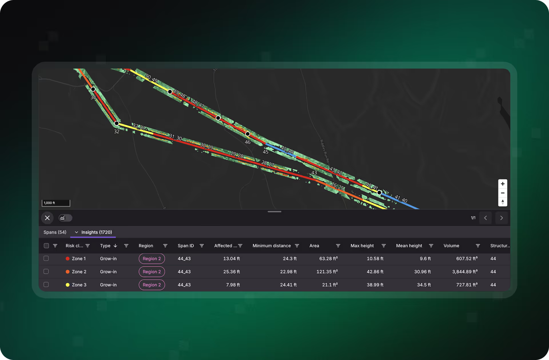
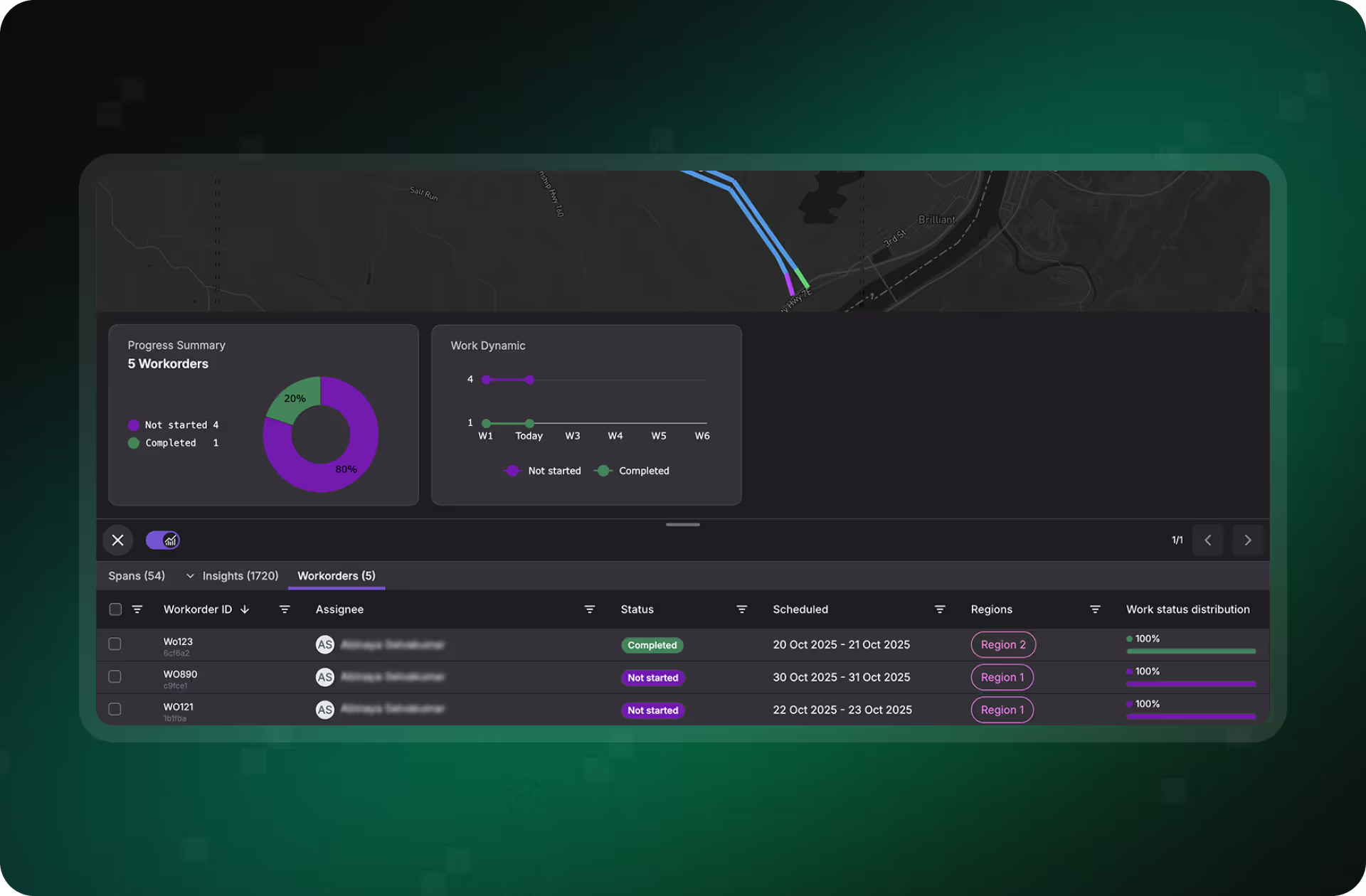
Turn Raw Data Into Actionable Insights
Treeline aggregates all vegetation analytics into a standardized, span-level view that can be filtered, sorted, and operationalized. Whether you’re planning trimming cycles or coordinating response, you’ll know which spans matter most.
- Centralized, up-to-date span-level risk dashboard
- Risk scoring based on height, proximity, and health
- Combines satellite, LiDAR, and patrol data in one interface
See Vegetation Risk Before It Becomes a Reliability Problem
Discover how Treeline’s AI-powered satellite detection helps utilities gain full-span visibility, detect hazardous vegetation earlier, and reduce reliance on costly manual inspections, all while improving resilience and compliance.
What Proactive Vegetation Risk Management Looks Like in Practice
See how real teams are transforming grid reliability with proactive, satellite-powered insights.
"The LiveEO technology gives us a better overview of the vegetation along our tracks. It allows us to address the consequences of climate change even better."


“Westerville Electric went with LiveEO and our outage rate in 2022 was 18%. We are now at 10%. This is the future of vegetation management!”

"The possibility to check our network with satellite images and AI as well as the strong customer focus of LiveEO have excited us from the beginning. Innovative partners like LiveEO and new technologies are an important pillar for us as a grid operator to make our network even more efficient and reliable."


.avif)
FAQs
Understand how Treeline detects vegetation threats before they escalate, from how it works to how it integrates with your existing systems.


What types of vegetation risks does Treeline detect?
Treeline detects fall-in, grow-in (horizontal and vertical encroachment), and hazard trees using AI-powered analysis of high-resolution satellite and elevation data. It can also assess vegetation health and, where available, classify vegetation types (e.g., conifer vs. deciduous).
How accurate is the detection?
Treeline uses validated AI models and 3D data sources to achieve high detection accuracy. Each insight includes transparency on detection confidence and coverage so utilities can prioritize with confidence.
How often is the data updated?
Imagery and risk insights are delivered on a recurring basis (e.g., quarterly or biannually), customizable to your vegetation cycles and regulatory requirements.
Can Treeline work with our LiDAR data?
Yes. Treeline complements and integrates LiDAR and other inspection datasets into a unified span-level view, helping teams bridge the gap between costly scan cycles.
Does this replace ground patrols or LiDAR?
Treeline doesn’t aim to replace these methods but significantly reduces their frequency and cost by offering scalable, in-between-cycle monitoring that extends situational awareness across the network.