
Full Visibility. Faster Response. Safer Gas Pipeline Networks.
SurfaceScout gives gas operators full visibility across pipeline corridors using satellite imagery and AI. Detect third-party activity and land movement in remote, urban, and restricted areas without expanding field operations.

Trusted by Leaders Worldwide


The Top Threats Undermining Pipeline Safety and Compliance
From remote terrain to regulatory risk, today’s operators face mounting pressure to monitor pipeline integrity more frequently, with fewer resources, all while minimizing environmental and reputational fallout.
Third-Party Interference Risks Are Increasing
Construction, excavation, and unauthorized activity near gas infrastructure pose immediate public safety risks. Without real-time visibility, even routine digging can trigger leaks, shutdowns, or worse.
Ground Movement Creates Hidden Hazards
Subsidence, erosion, or land use changes can compromise pipeline integrity, often undetected until it’s too late. Traditional inspections can’t scale to monitor these changes consistently.
Regulatory Scrutiny Is Intensifying
With mandates from PHMSA, local regulators, and global safety bodies, operators are under growing pressure to detect threats earlier, document responses, and prove compliance at every step.
Stay Ahead of Risk, Cut Costs,
and Protect Your Pipeline
SurfaceScout delivers a closed-loop solution that helps you detect, prioritize, and act on pipeline risks before they escalate.
Detect Critical Risks Sooner
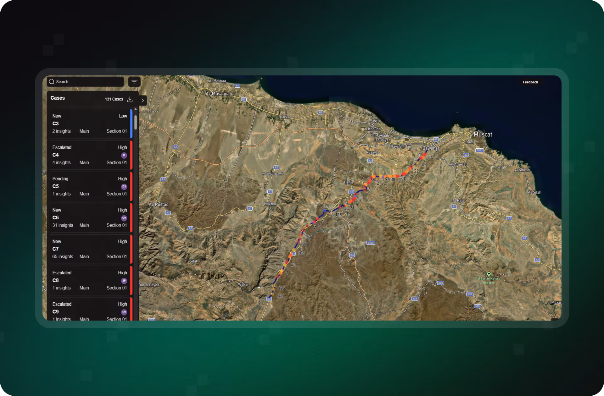
AI-powered risk detection with 100% corridor coverage, even in remote or restricted areas. Spot third-party threats and natural hazards faster using change detection across optical and SAR imagery.
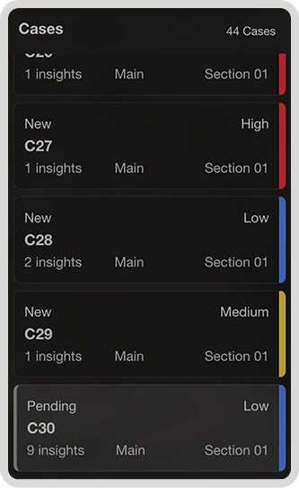
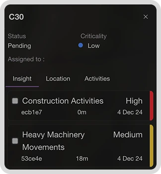
Prioritize and Act in Real Time
High-priority cases are automatically surfaced with criticality scoring. Manage investigations, assign field teams, and update case status, all in one shared interface across web and mobile.
Prove Compliance Without the Paper Chase
Each case is tracked from insight to resolution. Download detailed, timestamped reports in PDF or GeoJSON to streamline regulatory audits and internal reporting.
How We Keep Your Pipelines Safe
SurfaceScout delivers a complete solution for pipeline risk monitoring, from satellite-based detection to response coordination and compliance reporting. Every feature is built to reduce risk, save time, and keep your operations audit-ready.
Detect Hazards Before They Become Emergencies
Continuously monitor your entire corridor with satellite imagery and AI. SurfaceScout flags third-party activity and natural hazards early, no flyovers, no blind spots.
Turn Insights Into Coordinated Action
Create and manage cases in one place. Assign tasks, track updates, and collaborate across teams with real-time status changes and field-uploaded photos.
.avif)
Prove Compliance With Defensible Records
Log every decision and action, from risk detection to resolution. Export defensible records for audits, regulatory filings, or internal reviews.
.avif)
Reveal Hidden Patterns With Time-Sequenced Data
Use time-sequenced satellite imagery to detect gradual threats early. Build visual evidence for inspections and uncover trends patrols might miss.
Ready to Reduce Risk Across Your Oil Pipeline Network?
Whether you manage 500 km or 5,000 km, SurfaceScout delivers the scale, speed, and visibility to monitor risk without expanding field teams.
How Leading Pipeline Operators
Stay Ahead of Risk
Explore how teams like yours are transforming their risk workflows with satellite intelligence.


FAQs
From technical capabilities to compliance questions, we’ve got you covered. Whether you're evaluating SurfaceScout or preparing to roll it out across your network, these answers will help you understand exactly how our platform supports your pipeline safety, efficiency, and regulatory goals.


How is SurfaceScout different from aerial or drone inspections?
Satellite monitoring offers continuous, large-scale coverage without the cost, weather dependencies, or airspace clearance required for drones or helicopters. SurfaceScout enables proactive, consistent monitoring, not just periodic snapshots.
What types of risks can SurfaceScout detect?
SurfaceScout detects third-party threats like excavation, encroachment, and construction, as well as natural hazards such as erosion, landslides, and waterbody expansion. Our AI models are specifically trained to identify risk patterns across oil pipeline environments.
Do I need any special hardware or sensors in the field?
No additional hardware is required. SurfaceScout is entirely satellite-based and cloud-delivered. You don’t need to install or maintain any field equipment, it works out of the box with your existing GIS and inspection workflows.
How quickly can we take action on detected risks?
Insights are delivered in near real-time. Each alert includes location, context, and severity, allowing your field teams to respond within hours via our integrated web and mobile case management tools.
Is SurfaceScout compliant with PHMSA or international regulatory standards?
Yes. Every case and user action is timestamped and geotagged, with full export options (PDF, GeoJSON, CSV) for audits and compliance reviews. SurfaceScout supports PHMSA and similar global regulations by making reporting fast, traceable, and audit-ready.
Still have questions? We’re here to help. Reach out to our team for a personalized walkthrough or answers tailored to your operation.