Natural Hazard Monitoring

Spot Natural Hazards Before They Put Your Assets at Risk

Floods, landslides, wildfires, and subsidence rarely strike without warning, the early signs are visible long before disaster. SurfaceScout turns satellite imagery and AI into continuous hazard intelligence, detecting environmental changes across your corridors so you can act early, prevent costly disruptions, and protect both infrastructure and communities.

Contact us

Trusted by Leaders Worldwide

Our customer stories
The Problem

Hazards Build Long Before They Break

Floods, landslides, wildfires, and subsidence all leave visible precursors, yet most operators still rely on reactive monitoring. Static inspections and delayed reporting miss subtle environmental changes that can escalate into major failures, leaving infrastructure, communities, and budgets at risk.

Hazards Compound Over Time

Natural processes like soil creep, gradual erosion, or vegetation die-off build silently over weeks or months. Without continuous monitoring, these small changes are invisible until they trigger landslides, sinkholes, or fire outbreaks.

Climate Extremes Amplify Risk

More frequent storms, floods, and heatwaves disrupt the reliability of risk models based on historical averages. Operators face an evolving risk landscape that outpaces static monitoring methods.

Emergency Response Dominates Budgets

Hazard damage often requires urgent, large-scale interventions, road closures, emergency crews, and environmental cleanups, that cost multiples more than proactive mitigation would.

Limited Data on Remote Terrain

Mountainous spans, river crossings, and fire-prone wilderness are the hardest to inspect yet the most vulnerable to natural forces. Sparse data from these areas creates blind spots that delay detection of critical risks.

One Event Can Spark Another

A wildfire destabilizes slopes that later collapse in heavy rain; a flood weakens soil that leads to subsidence. These cascading effects are difficult to track without high-frequency, wide-area visibility.

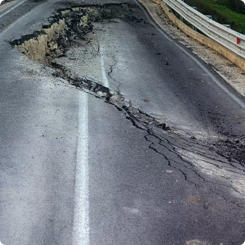
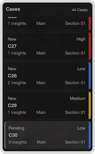
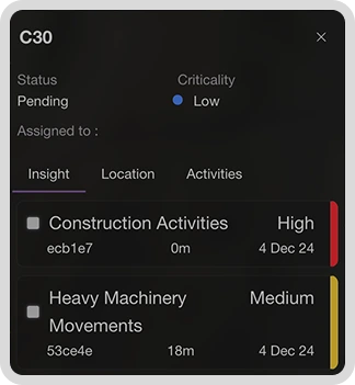
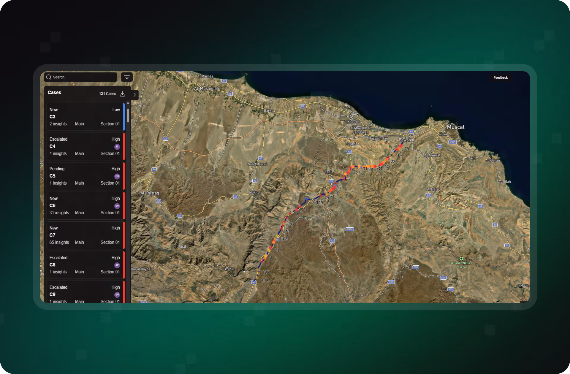
How Operators Stay Ahead of Natural Hazards with SurfaceScout

SurfaceScout equips operators with the tools to spot, track, and respond to natural hazards before they become costly crises. By combining satellite imagery with AI-driven analysis, it delivers continuous oversight of vulnerable corridors, early warnings of environmental change, and audit-ready records of every mitigation step.

Automated Risk Detection and Prioritization

Detect Hazards Before They Become Emergencies

Continuously monitor your entire corridor with satellite imagery and AI. SurfaceScout flags third-party activity and natural hazards early, no flyovers, no blind spots.

Learn more
Integrated Case Management

Turn Insights Into Coordinated Action

Create and manage cases in one place. Assign tasks, track updates, and collaborate across teams with real-time status changes and field-uploaded photos.

Learn more
Audit-Ready Reporting

Prove Compliance With Defensible Records

Log every decision and action, from risk detection to resolution. Export defensible records for audits, regulatory filings, or internal reviews.

Learn more
Historical Change Analysis

Reveal Hidden Patterns With Time-Sequenced Data

Use time-sequenced satellite imagery to detect gradual threats early. Build visual evidence for inspections and uncover trends patrols might miss.

Learn more

Build Resilience Before the Next Hazard Strikes

Natural events don’t have to become emergencies. With SurfaceScout, you gain early warning of floods, fires, and landslides, so you can protect assets, safeguard communities, and reduce recovery costs before disasters unfold.

Contact us
Case Studies

Smarter Pipeline Monitoring in Action

Discover how operators are using SurfaceScout’s satellite- and AI-powered monitoring to detect third-party threats early, reduce inspection costs, and safeguard pipeline integrity at scale.

Ontras Case Study - Leveraging Ground Deformation Monitoring for Rerouting Decisions. Find out what it means for you.
Read more
MITNETZ GAS Case Study - Enhancing Pipeline Monitoring with Satellite Technology. Explore insights you can’t miss.
Read more

FAQs

Get answers on how SurfaceScout helps operators anticipate floods, landslides, wildfires, and other natural hazards before they escalate into costly disruptions.

Still have questions?
Contact us
No items found.