How Utilities Plan Smarter With Treeline
By combining satellite imagery, AI, and multi-factor scoring, Treeline helps utilities identify high-risk spans, forecast clearance issues, and align crews around the areas that matter most.
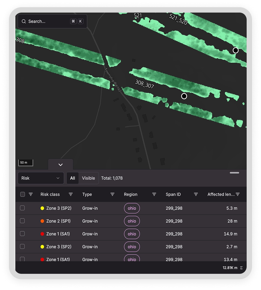
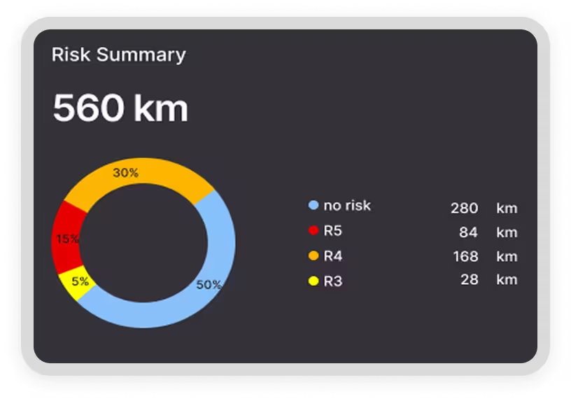
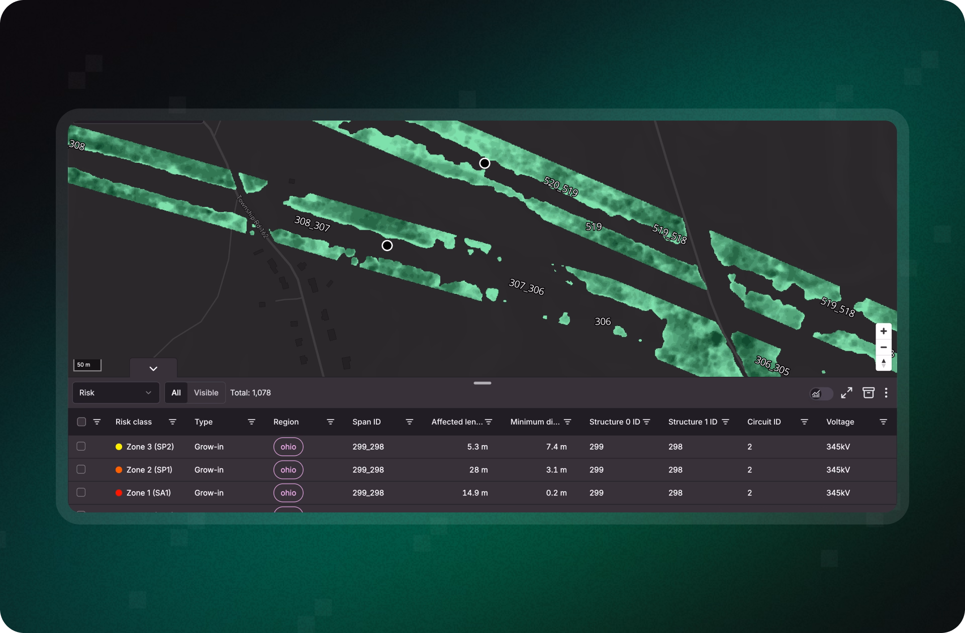
Using satellite imagery and AI, Treeline scores every span by risk type, proximity, and asset criticality, giving managers a clear risk map to plan effectively by prioritizing high-risk spans, allocating resources wisely, and directing crews where they’re needed most to cut cost and improve reliability.
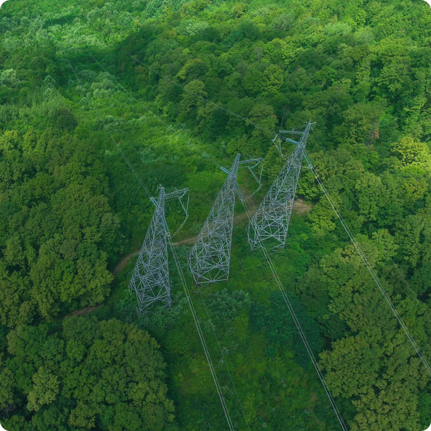


Vegetation management decisions are only as strong as the data behind them. But with data fragmented across patrol reports, aerial surveys, and contractor notes, utilities rarely have the full picture of where risk truly lies. That lack of visibility forces crews into reactive work, spreads budgets too thin, and allows high-risk spans to slip through unnoticed, until they become outages, compliance failures, or costly emergency interventions.
Patrol reports and spot checks provide isolated snapshots, not a complete view of issues or how they compare across the network. Without a holistic risk view, planners struggle to direct crews toward the spans that matter most, driving up costs while critical spans go untreated.
Siloed Data Blocks Long-Term Strategy
Vegetation data is often locked in district- or vendor-specific systems, making benchmarking and consistent planning nearly impossible. This fragmentation prevents utilities from building long-term strategies and leaves leadership without the defensible insight regulators demand.
No Forecasting Means Constant Catch-Up
Traditional approaches stop at “what’s there now.” Without forecasting future clearance risks, utilities stay stuck in a cycle of catch-up, where risks escalate between cycles and budgets are consumed by unplanned interventions instead of proactive planning.
How Utilities Plan Smarter With Treeline
By combining satellite imagery, AI, and multi-factor scoring, Treeline helps utilities identify high-risk spans, forecast clearance issues, and align crews around the areas that matter most.


Build the Foundation for Smarter Planning
Treeline continuously detects grow-in, fall-in, and hazard trees across the network. By replacing partial snapshots with complete, system-wide visibility, planners finally get a reliable baseline for prioritization and long-term vegetation strategy.
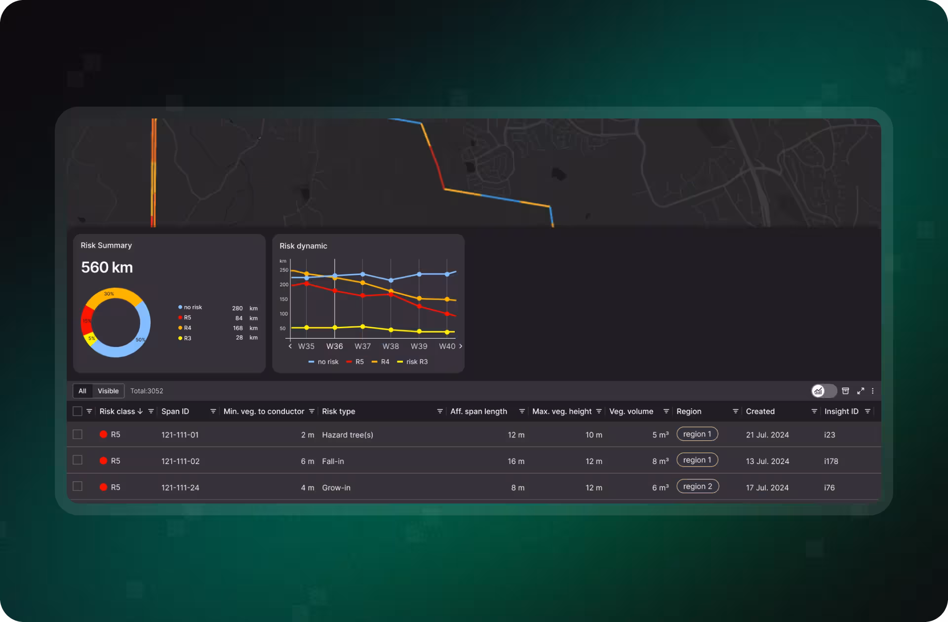
Rank Spans by Real Risk, Not Guesswork
Each span is scored through a multi-factor model that considers vegetation type, growth rate, proximity, and grid criticality. Interactive dashboards and exportable work items give planners a clear hierarchy of risk, helping direct crews and budgets toward the spans most likely to cause outages.
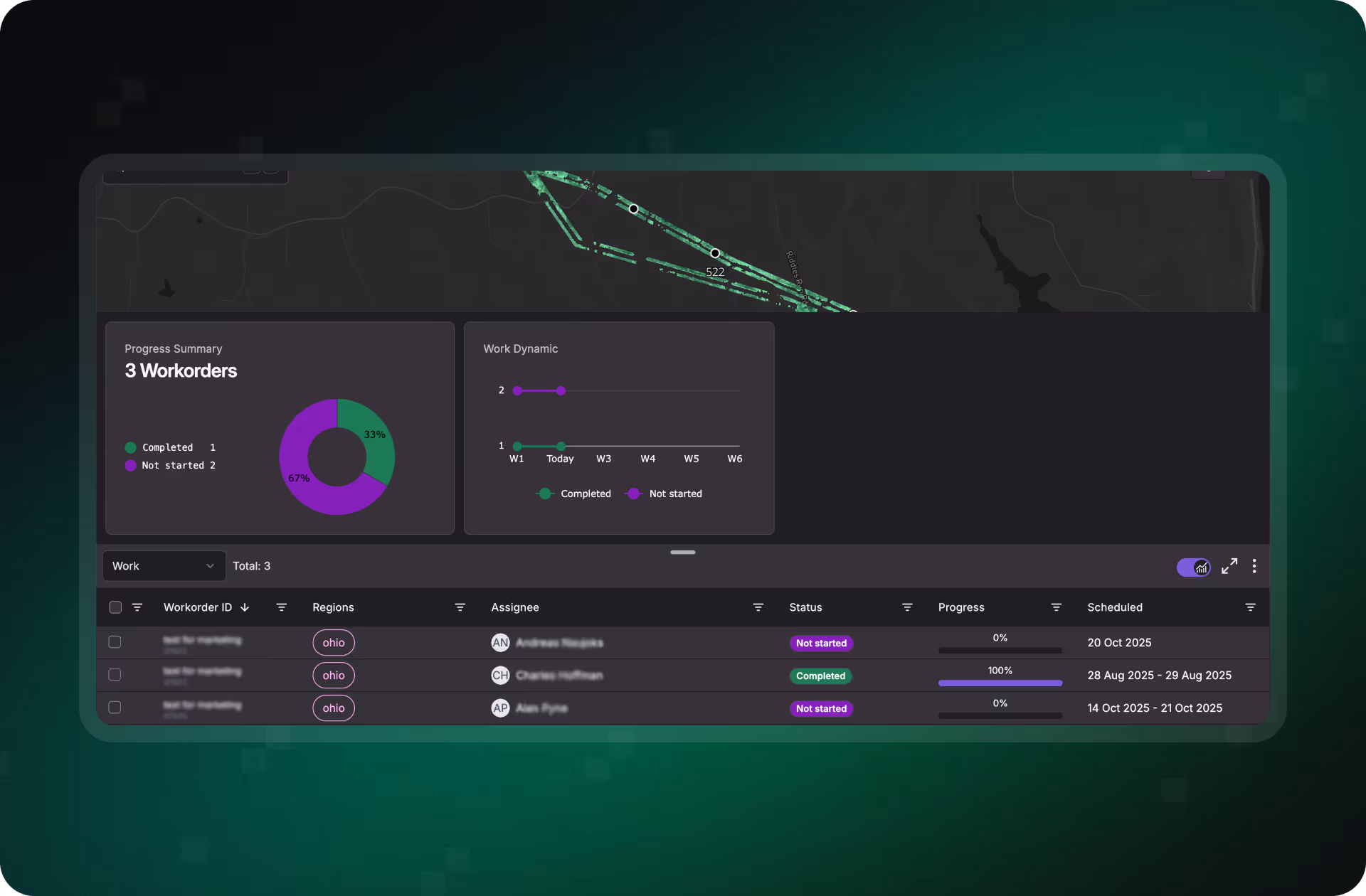
Turn Risk Maps Into Targeted Work Plans
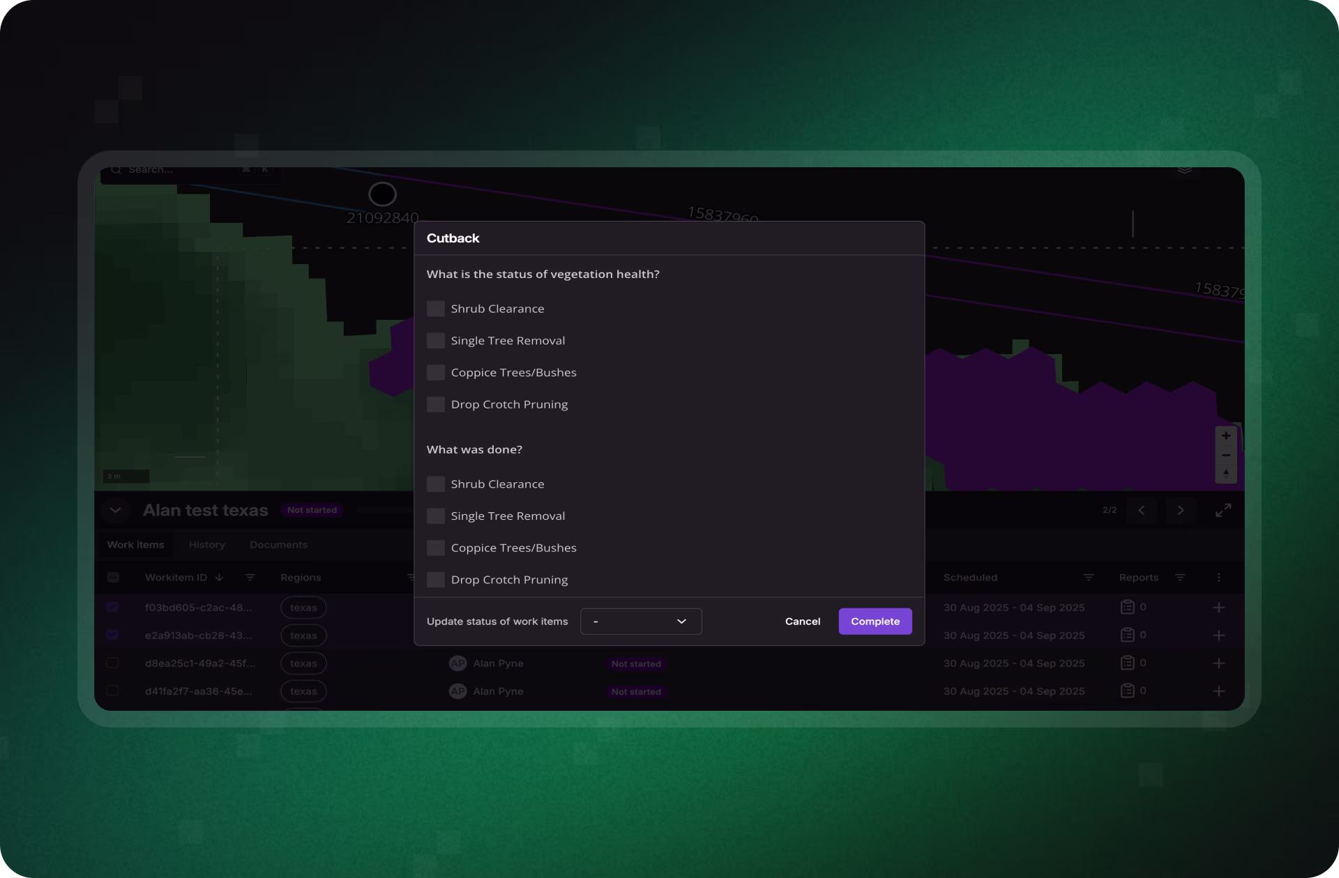
Treeline converts prioritized risks into map-based work orders with built-in QA and context. Crews receive clear instructions, supervisors see progress in real time, and every intervention is logged with proof, ensuring resources are allocated effectively and consistently.
Demonstrate Smarter Decisions With Transparent Data
Treeline streamlines reporting by tying every planning decision to clear, defensible evidence. From consolidated dashboards to export-ready reports, utilities can show exactly how fragmented inputs were unified, risks prioritized, and budgets aligned with reliability goals.
Stop treating every span the same. Treeline gives you a clear, data-backed view of where vegetation risk is highest, so you can prioritize confidently, optimize budgets, and reduce costly surprises.
Smarter Vegetation Management in Action
See how utilities are using Treeline’s satellite- and AI-powered vegetation insights to cut inspection costs, reduce wildfire risk, and improve grid reliability.
"The LiveEO technology gives us a better overview of the vegetation along our tracks. It allows us to address the consequences of climate change even better."


“Westerville Electric went with LiveEO and our outage rate in 2022 was 18%. We are now at 10%. This is the future of vegetation management!”


"The possibility to check our network with satellite images and AI as well as the strong customer focus of LiveEO have excited us from the beginning. Innovative partners like LiveEO and new technologies are an important pillar for us as a grid operator to make our network even more efficient and reliable."


Get answers on how Treeline helps utilities prioritize vegetation risk, unify fragmented data, and plan smarter with predictive insights.
Treeline scores every span based on vegetation type, growth rate, proximity, and asset criticality, giving planners a clear hierarchy of where action is most urgent.
Yes. Treeline unifies vegetation insights into a single system-wide view, making it possible to compare risks, benchmark performance, and build long-term strategies.
Treeline goes beyond snapshots of “what’s there now” by modeling growth trends and clearance risks over time, helping utilities plan ahead instead of reacting after risks escalate.
Absolutely. Treeline connects with GIS and WFM platforms like ESRI, SAP, Trimble, and Clearion, turning prioritized risk insights directly into actionable work orders.