Catch Vegetation Hazards Before They Cut Power
Treeline uses satellite imagery and AI to monitor fall-in, grow-in, overhang, and hazard tree risks across your entire network, so you can act before they cause disruptions. Replace reactive cleanups with proactive prevention.


Trusted by Leaders Worldwide


Outages Don’t Start With Trees,
They Start With Missed Detection
While conditions are becoming more challenging with extreme weather, vegetation threats don’t usually happen overnight. The warning signs, leaning trees, growing encroachments, dying canopies, often emerge well before an outage. But with patrol-based monitoring, those signs are often missed. Limited visibility, delayed inspections, and reactive response windows leave utilities exposed to preventable disruptions, costly callouts, and compliance risk.
Critical Risks Emerge Between Inspections
Scheduled inspections leave long gaps without visibility. In that time, encroachments or hazard trees can go from manageable to critical, causing outages and requiring urgent, expensive interventions. Treeline closes those gaps with continuous monitoring.
Remote Corridors Leave the Biggest Blind Spots
Remote and rugged spans are often inspected the least, leaving them more exposed to undetected risks. These blind spots are especially dangerous during fire season or extreme weather. Treeline provides consistent visibility, even in hard-to-reach areas.
Delayed Detection Means Reactive Response
Without continuous monitoring, crews often discover threats only when lines are already compromised or clearances are critically low. By then, it’s no longer prevention, just costly, reactive cleanup. Treeline detects risks early so you can act before outages occur.
Missed Vegetation Risk Drives Up Cost and Liability
Outages trigger customer complaints, regulatory inquiries, and reputational damage. Treeline helps you shift from "how did we miss this?" to "we detected it early and already resolved it.
How Utilities Prevent
Vegetation-Related Outages with Treeline
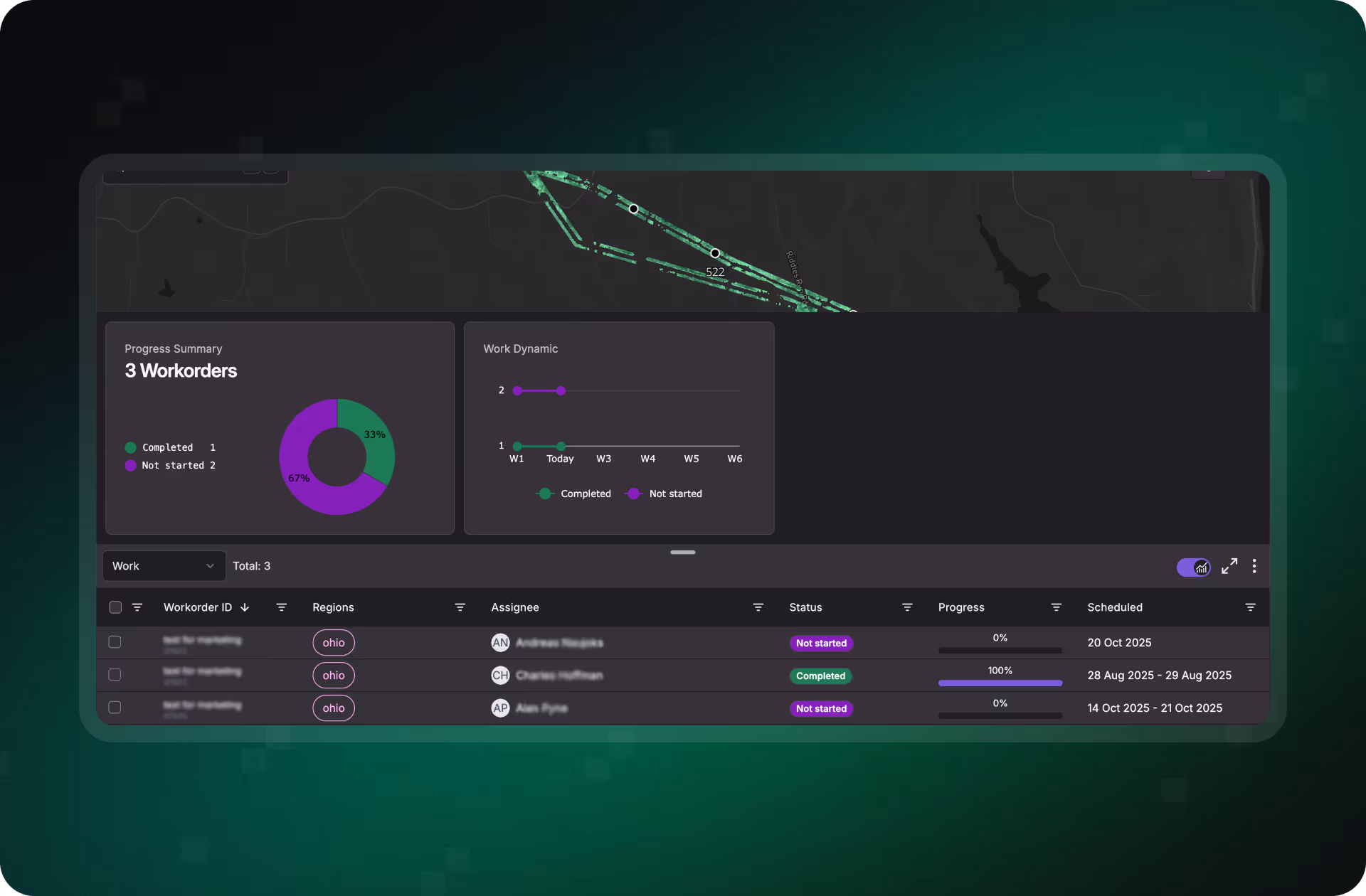
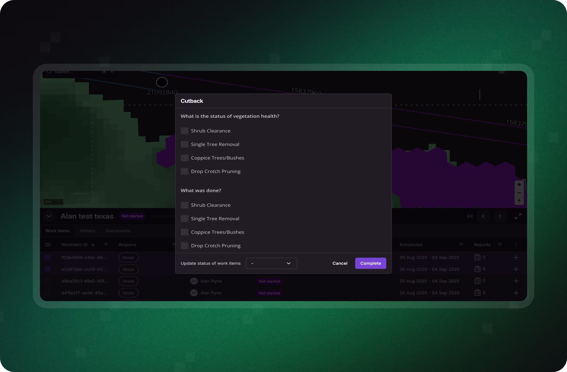
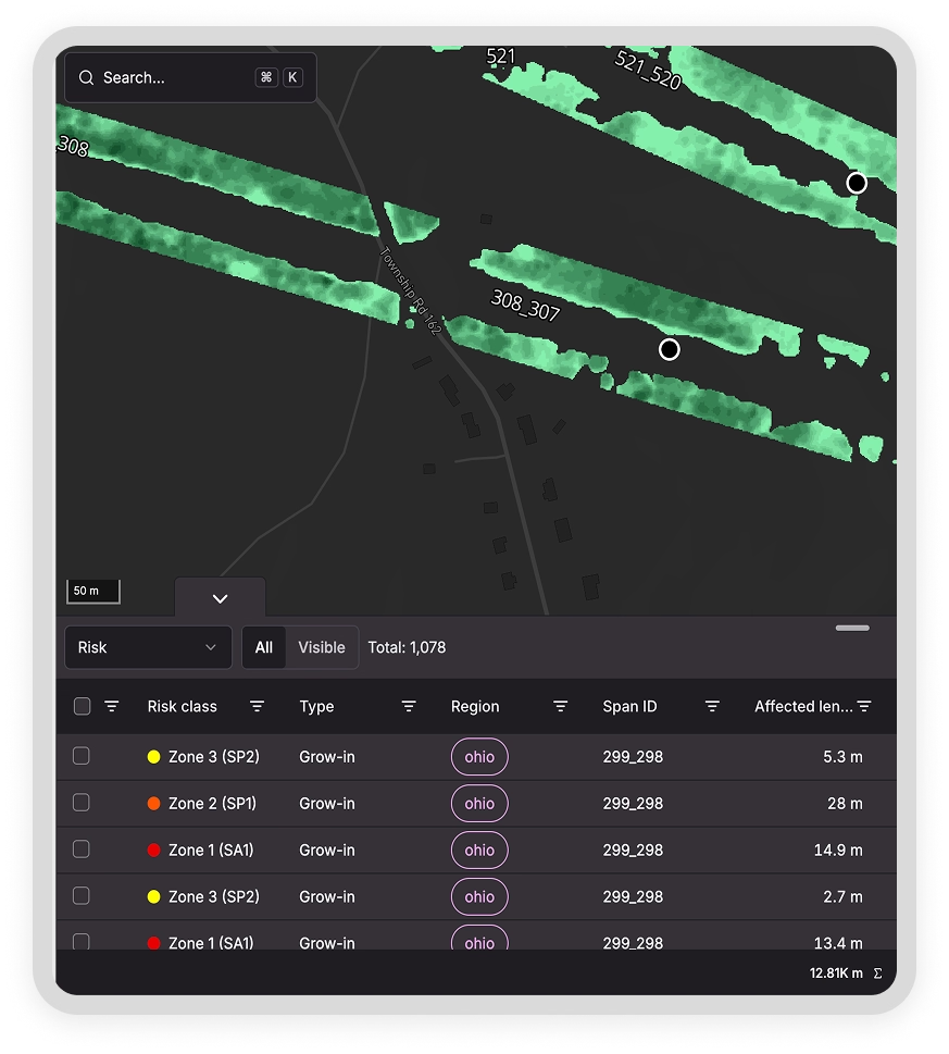
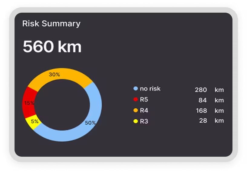
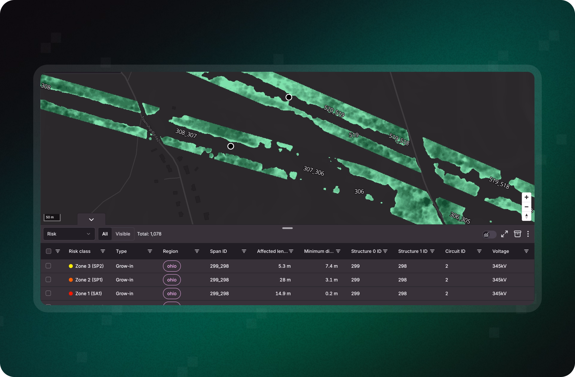
Treeline gives utilities the satellite-powered visibility and risk intelligence to detect vegetation threats before they escalate. From hazard tree detection to span-level risk prioritization and verified mitigation, Treeline helps teams stay ahead of outages, reduce emergency response, and strengthen system reliability.


Detect Vegetation Threats Before They Disrupt Your Network
Treeline continuously scans for grow-in, fall-in, and hazard trees across the entire network. By surfacing risks as they emerge, not months after inspections, utilities can prevent clearance violations and outages before they disrupt service.

%20for%20prioritization.avif)
Focus Crews on Spans Most Likely to Cause Outages
Every span is scored using a multi-factor risk model that weighs vegetation type, growth rate, proximity, and grid criticality. Color-coded dashboards and exportable work items highlight the spans most likely to cause outages, so resources go where they’ll have the greatest reliability impact.


Turn Early Warnings Into Preventive Action
Treeline transforms outage risks into clear, map-based work orders with full context and built-in QA. Crews receive precise instructions, supervisors monitor progress in real time, and every mitigation is verified with GPS- and photo-based proof, reducing emergency callouts and unplanned downtime.


Demonstrate How Proactive Action Prevents Disruptions
From dashboards to export-ready reports, Treeline makes it easy to show how early detection and targeted action prevent outages. Every job is logged with defensible evidence, giving teams visibility into what was fixed, where, and why, while reinforcing customer and stakeholder trust in reliability efforts.
Prevent the Next Outage Before It Starts
Don’t wait for the next inspection to find the next risk. Treeline gives utilities continuous visibility into vegetation threats, so you can act early, avoid emergency interventions, and keep the grid reliable year-round.
Smarter Vegetation Management in Action
See how utilities are using Treeline’s satellite- and AI-powered vegetation insights to cut inspection costs, reduce wildfire risk, and improve grid reliability.

"The LiveEO technology gives us a better overview of the vegetation along our tracks. It allows us to address the consequences of climate change even better."

“Westerville Electric went with LiveEO and our outage rate in 2022 was 18%. We are now at 10%. This is the future of vegetation management!”

"The possibility to check our network with satellite images and AI as well as the strong customer focus of LiveEO have excited us from the beginning. Innovative partners like LiveEO and new technologies are an important pillar for us as a grid operator to make our network even more efficient and reliable."
FAQs
Get answers on how Treeline helps utilities detect wildfire risks earlier, focus mitigation where it matters, and prove prevention to regulators and insurers.
How does Treeline help prevent vegetation-related outages?
Treeline uses AI and satellite imagery to detect fall-in, grow-in, overhang, and hazard trees across your network, even between patrols or in hard-to-reach areas. This allows teams to act before clearance violations occur.
Can Treeline monitor remote or hard-to-access corridors?
Yes. Treeline covers wide geographies, including remote and mountainous terrain, with consistent visibility, helping identify risks that traditional inspections often miss.
Will Treeline reduce emergency response costs?
By detecting risks earlier, Treeline helps utilities proactively address issues before they require urgent intervention, lowering emergency callouts and improving budget predictability.
How often is vegetation risk data updated?
Treeline delivers vegetation risk insights on a recurring cadence (e.g., quarterly or semiannually), tailored to your vegetation growth patterns, risk zones, and operational priorities.
Does Treeline integrate with our existing systems?
Yes. Treeline integrates with common GIS and WFM platforms like ESRI, SAP, Trimble, and Clearion. Insights can be exported as work orders or synchronized via API for seamless planning and execution.
How does Treeline support FAC-003 compliance?
Treeline provides span-level documentation of vegetation conditions and mitigation activities, including before/after photos, timestamps, and clearance evidence. This helps utilities meet NERC FAC-003 audit requirements with defensible, exportable records.