
Smarter Work Management for a Safer, More Reliable Grid
Treeline transforms vegetation work management by turning every risk insight into a traceable, map-based work order. Assign tasks, track progress, and verify completion with timestamped updates and GPS-tagged photos, all in a unified workflow that keeps field crews and planning teams in sync.

Trusted by Leaders Worldwide


Align the Field With the Plan
and Prove It Got Done
When vegetation work lacks clear scope, structure, or verification, teams end up misaligned. Treeline’s work management tools give field crews the exact context they need, while supervisors get real-time visibility into progress and QA. The result: fewer disputes, faster resolution, and a shared source of truth from assignment to audit.
No Context, No Clarity, More Rework
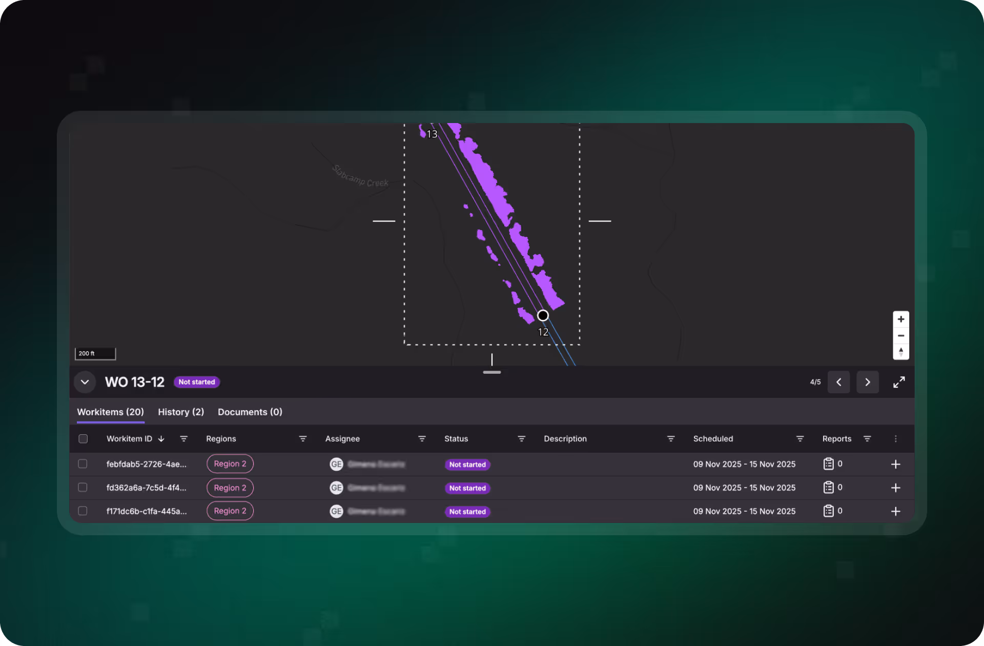
Crews often operate with vague instructions and limited span-level visibility. Treeline packages each insight into a work item with full context and map-based routing, reducing confusion and keeping work aligned with the original risk.
No Real-Time View = No Real Oversight
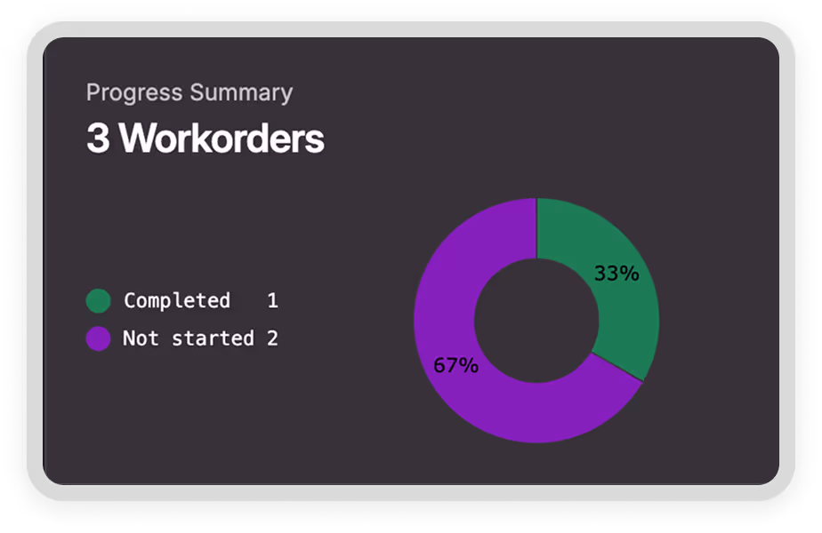
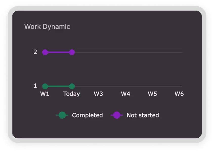
Supervisors can’t manage what they can’t see. With live dashboards and mobile updates, Treeline shows what’s happening in the field so leaders can track progress, spot issues, and course-correct early.
Disputes and Rework Drain Resources
Without structured QA and timestamped proof, performance disputes are common and costly. Treeline builds validation into every work order with checklists, photos, and GPS-tagged updates that back up every decision.

"LiveEO’s technology has the potential to drive down our SAIDI and SAIFI, reduce service restoration costs, and help us allocate resources more effectively during storm restoration efforts, making it an invaluable tool for improving our overall system reliability and customer satisfaction...”

.webp)
Streamline Field Execution With Connected, Verifiable Workflows
With real-time visibility, standardized documentation, and two-way integration with WFM and GIS tools, utilities can align teams, reduce rework, and validate every completed job.
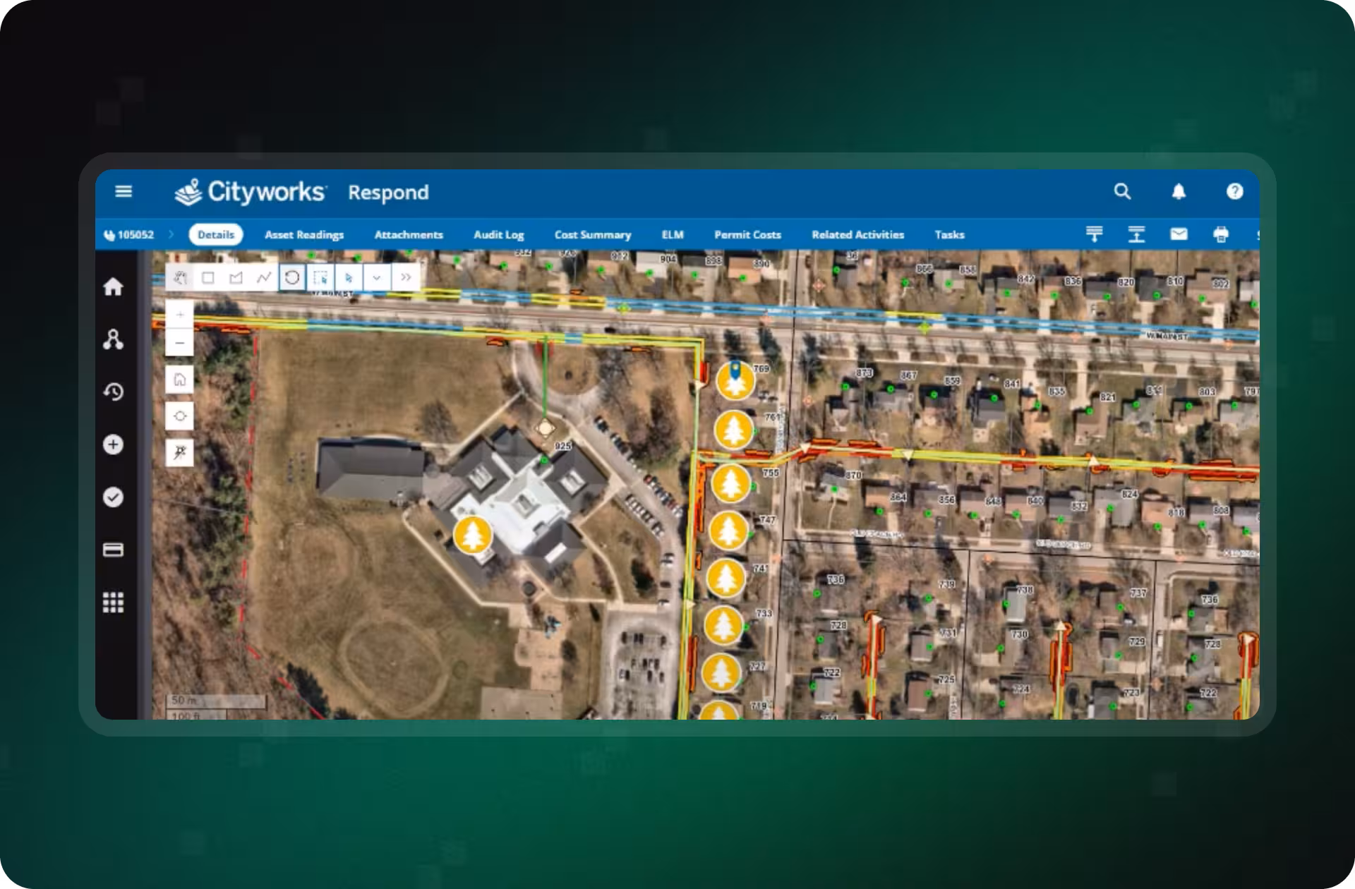
Assign Smarter With Spatial Context
Every Treeline insight becomes a georeferenced work item, complete with span-level detail and routing context. Crews know exactly where and why they're working, reducing confusion, scope creep, and wasted truck rolls.
- Visualize and package work in web and mobile
- Include span/asset context and routing
- Improve first-time resolution rates
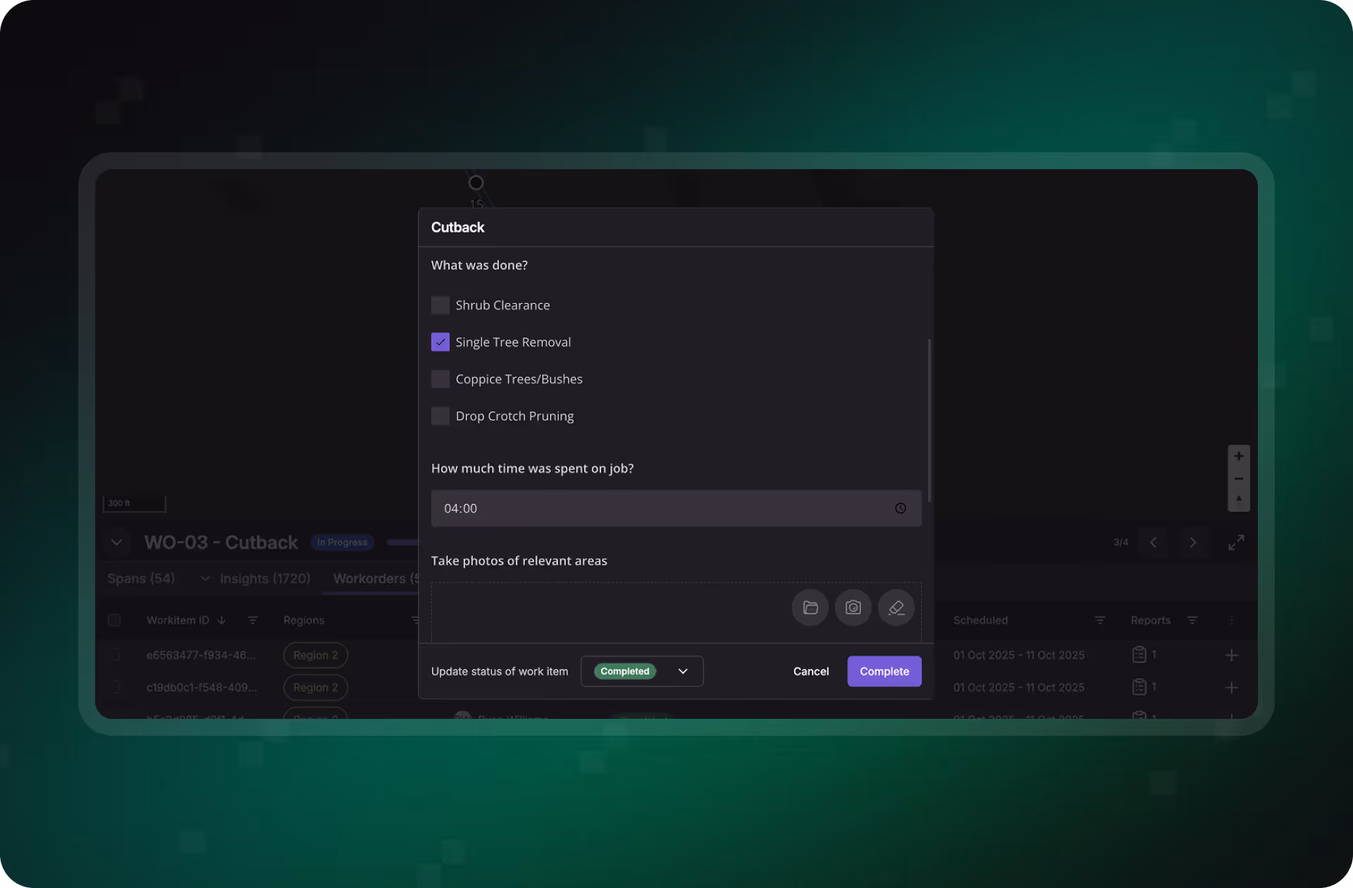
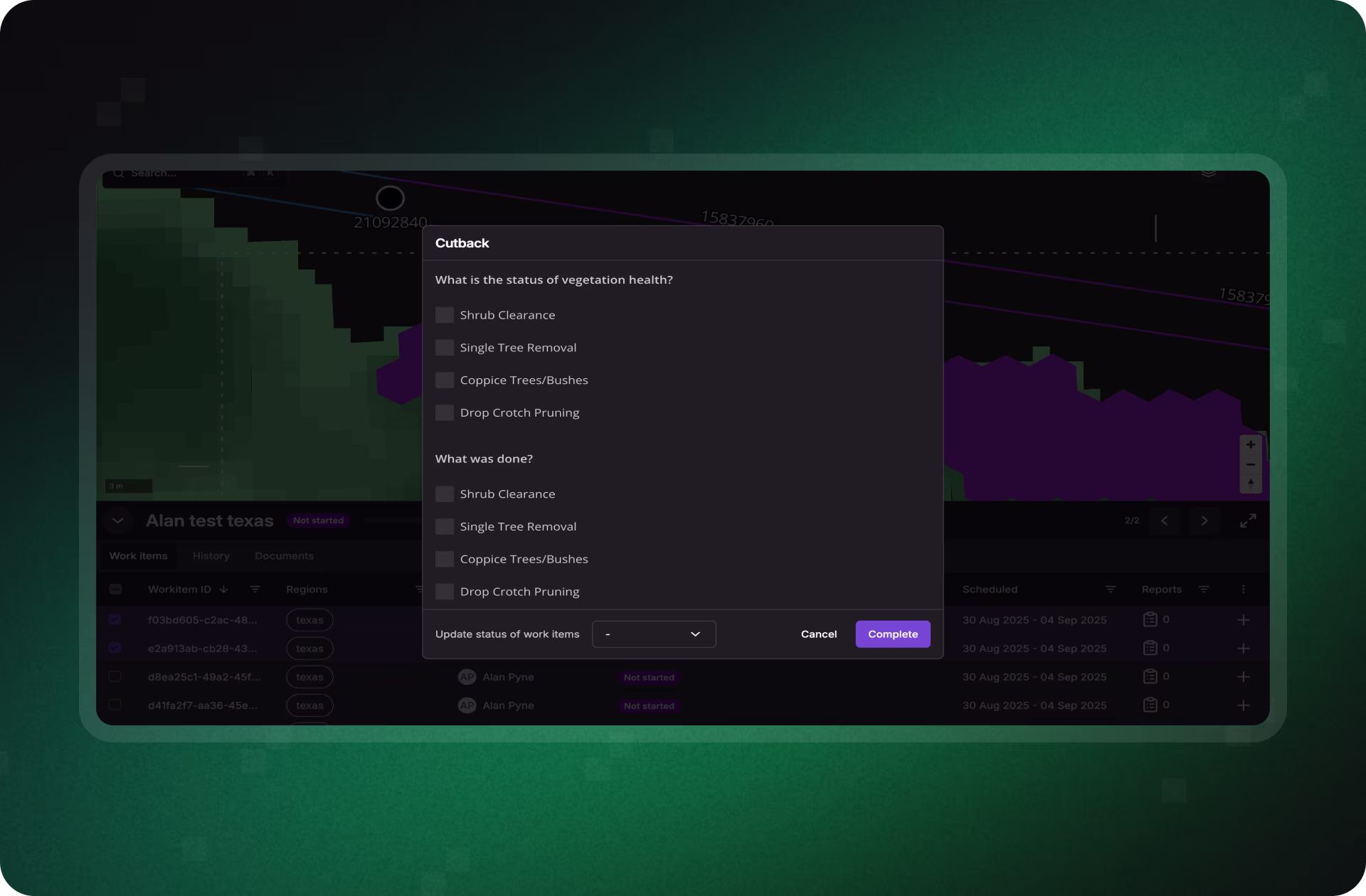
Standardize How Work Gets Done and Proven
Treeline embeds QA into every task with structured checklists, before/after photo capture, and GPS-tagged updates. Supervisors get timestamped proof of work, helping resolve disputes and validate contractor performance.
- Structured inspection forms and image comparison
- Timestamped, location-based updates
- Transparent record of execution and quality
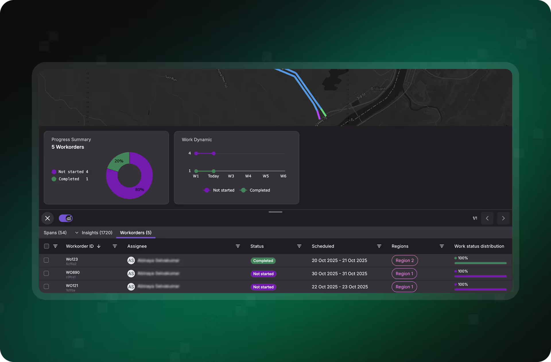
See What’s Happening, As It Happens
With Treeline’s supervisor dashboard, planners and managers can monitor job status, track team progress, and intervene when needed, no more blind spots between the office and the field.
- Live work status across mobile and web
- Monitor completions, delays, and blockers
- Keep projects on track and in compliance
Sync With Your Existing WFM and GIS Stack
Treeline supports bi-directional sync with systems like ESRI, SAP, Clearion, and Trimble, aligning vegetation work orders, documentation, and status changes across platforms.
- API-based sync for geometries, docs, and statuses
- Integrates with major GIS and WFM tools
- Keeps field and office in lockstep
Connect Field Teams. Close Out Work With Confidence.
Discover how Treeline helps utilities assign, verify, and track vegetation work, all in one platform. From map-based routing to QA-ready photo logs, you’ll reduce rework, increase transparency, and ensure every job meets standards the first time.
What Smarter Vegetation Management
Looks Like in Practice
Explore how teams are cutting delays, avoiding disputes, and aligning field crews and planners around a single source of truth.
"The LiveEO technology gives us a better overview of the vegetation along our tracks. It allows us to address the consequences of climate change even better."


“Westerville Electric went with LiveEO and our outage rate in 2022 was 18%. We are now at 10%. This is the future of vegetation management!”


"The possibility to check our network with satellite images and AI as well as the strong customer focus of LiveEO have excited us from the beginning. Innovative partners like LiveEO and new technologies are an important pillar for us as a grid operator to make our network even more efficient and reliable."


.avif)
%20for%20prioritization.avif)
FAQs
Understand how Treeline streamlines vegetation work execution, from work order creation to mobile field updates and QA tracking, all while integrating with your existing systems.


How are work orders generated in Treeline?
Each verified vegetation risk is converted into a discrete work item, tied to a specific span or asset. These work items are packaged into route-based orders that crews can access via web or mobile, complete with map context and span-level details.
Can crews update work orders from the field?
Yes. Crews can log progress, upload photos, and complete structured QA checklists directly from the Treeline mobile app. All updates are timestamped and GPS-tagged for full traceability.
How is work status tracked in real time?
Supervisors can monitor progress through a live dashboard that shows work status by crew, span, or region. This visibility helps identify bottlenecks, verify quality, and avoid rework.
Does Treeline integrate with our existing WFM or GIS tools?
Treeline supports two-way syncing with leading systems like ESRI, SAP, Trimble, and Clearion. Work status, geometries, and documentation flow seamlessly between platforms, ensuring consistent data across your ecosystem.
How does Treeline help with quality assurance?
Treeline includes structured QA tools like before/after photo comparisons, customizable checklists, and supervisor sign-offs, all tied to each work item for defensibility and audit readiness.